Evening Star Newspaper, September 29, 1935, Page 75
You have reached the hourly page view limit. Unlock higher limit to our entire archive!
Subscribers enjoy higher page view limit, downloads, and exclusive features.
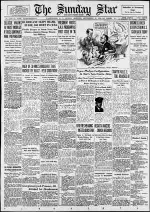
By John C. Henry. | HREE focal points of an em- sets today are shaded with the dull gray of fighting ships. tension of war has been noticeable for weeks while two great nations themselves meanwhile into an en- tangling web wherein will be deter- world powers. The three strategic spots are Gi- iterranean Sea; Malta, island naval base, and Port Said, doorway to the which the Mediterranean countries | must pass to reach the east coast of Orient. The fighting ships are those of the British empire, the plotting ognize the supreme importance of these three vantage points of war. stand like policemen with their faces | turned to Rome and the glitter of | only by their pleasure may his black- shirted legions pass to press their war More than that, they say further that in their being rest the colonial volved. For many years they have been the arteries through which African and Asiatic colonies as it | made its way from the empire’s heart | fall at the hands of Italy would mean simply & transfer of their importance Most familiar, perhaps, to a public consciousness that is thousands of pire on which the sun never Within their immediate limits, the plotted attack and defense, drawing mined their future status among the braltar, western sentinel of the Med- Buez Canal, itself the corridor through Africa and the rich ports of the that of Britain and Italy as they rec- Now in possession of Britain, they their guns saying to Mussolini that in Ethiopia. fortunes of the two nations now in- coursed the lifeblood of Britain's | to the tips of its fingers. Their down- | from one nation to another. miles removed from the actual scene | of warlike operations, is the Rock of | Gibraltar, around which an aure of | impregnable strength has been devel- oped since as far back as the eighth century. FOR all these centuries, the rock and | its fortifications have stood as the not always benign guardian of the| narrow straits between Spain and the African headlands, the only direct passage between the Atlantic Ocean | and the Mediterranean Sea. Maintained as & crown colony, the | ‘whole territory of Gibraltar is slightly less than 3 miles in north and south | length and a maximum of % of a| mile wide. Of this area, the rock it- | self is about 22 miles long, rising| almost perpendicularly from the sea- | way to the south and from a low sandy plain to the north. At its highest point, O’Haras Tower, the | rock rises some 1408 feet above sea level. Near this point stands the! A signal station where the name and destination of every passing ship is taken, recorded and flashed to-all parts of the world. At the southernmost cliff is Europa Point lighthouse, a short 11 miles from Africa. On the east side the rock descends THE SUNDAY STAR; WASHINGTON, D. C., BEPTEMBER 29; .1935—PART FOUR, l s reversal in 1704 when British and Dutch forces joined to effect its cap- ture after a three-day siege and the raising of the British flag brought the Rock under domination of an | empire which has guarded it jealously | and well ever since. | | with the same sharpness into the | | Mediterranean, but on the west the | MANY attempts occurred during the slopes are gentler and here is located | next 80 years to bring the fortress | the small town, principally military in | pack to Spanish control, and even to | population. Beyond this settlement, in the shelter of Gibraltar Bay, and with the further protection of encir- cling sea walls that shelter it from the anger of the nearby Atlantic, is | the anchorage where any portion of Britain’s fleet may ride securely. The rock itself consists of limestone, topped with layers of dark shale. Many caves, some of them of great dimen- sions. penetrate the interior. As for climate, inhabitants of the rock enjoy mildness in Winter and only moderate heat in Summer, BECAUSE of its military character, the territory proper is a residence only for those who hold special per- mits from the British government. From the neighboring Spanish towns of San Roque and La Linea de la Con- cepcion, however, comes an army of daily workers who remain within the | territory until “first evening gunfire,” | shortly after sunset. At that hour the gates to the mainland are closed and Gibraltar becomes virtually a military reservation. In its fortifications Gibraltar has kept some measure of pace with the development of implements of war. High up near the crest of the rock are modern guns; their range sub- stantially increased by their elevation. In the harbor, however, is the most effective element of military value, with 440 acres of water being inclosed | by the sheltering sea walls. Of this area, 250 acres have a low-water depth of 30 feet, sufficient for the largest fighting ships of the world’s largest fleet. Sixty-four acres of reclaimed water front have been turned into dock space, repair yards and auxiliary shops designed to service a fleet. The history of the rock is of fhore Interest than its geograpny. As a cen- ter of military operations, it gained its initial fame in the year 711 A. D, when Tariq crossed from Africa with an army of 12,000 Arabs and Berbers and defeated the Goths in a three- day battle near the rock. His next move was to fortify the rock and its military strength has grown constantly since. From 1300 until 1700, there occurred frequent sieges and several changes in control of this powerful outpost, the seventeenth century ending with it in the hands of the Spanish crown, and with its legend of impregnability well established. This claim euffered | the French, but so stoutly has it been _ | defended that only one of these even brought temporary success. This was during the years 1779 to 1783 when | the British government was direct- ing most of its attention to war in| America. During that period, Span- | ‘lsh and French attackers joined in a | relentless siege which was climaxed by a long naval bombardment in July, 1782. Defense use of red-hot | shot and successful experimentation | with elevated guns, however, proved | a turning point and the siege was raised soon after. Since 1783, the| history of the Rock fortification has been uneventful as it served its | menacing purpose of guarding the | entrance to the Mediterranean Sea, | | assuring safe passage to the ships of | Britain and her colonies as they ex- changed commercial visits. Nearly half way from Gibraltar to the entrance of the Suez Canal, and ominously close to Sicily and the toe of the Italian boot, lies the Island of Malta, one of a group of three islands all coming under the paternal wing of the far-seeing British govern- ment. Offshore from Valletta, prin- cipal city of the group, is one of the finest natural harbors in the Mediter- ranean, scattered along the other | shore lines are numerous other bays and inlets, all adaptable to ships of commerce—or of War. In the grand harbor of Valletta, also, rides a floating dock capable of | lifting the greatest warships for re- pairs, around its shore line are fuel- ing stations and other accessories necessary to the maintenance of & fleet that is many miles away from its home ports. At nearby Hal Far, inland from | Valletta on this island of only 91 square miles, is a fully equipped air- fleld, a partial answer from Britain to Italy’s gestures of combat in the air. From it already arise British planes to join in maneuvers with the grim gray ships that have been idling in Malta’s harbors, not more than 60 miles from Sicily, less than 150 from the Italian mainland. Standing at the crossroads of the Mediterranean, Malts has played a fascinating part in the history of.the Old World. Today it offers & race of people not matched exactly in any other place, their upper classes boast- ing the blood of Normans, Spaniards Gibraltar, Malta and Suez, Potent Forces for e Peace or Aids During Strife, Stand as Mighty : Sym Shadows of Great, Gray Warcraft. ing their ancestry to the Knights of | Mohammedan influence into South- ) being forced to wait some 10 cen- St. John and the heroic adventures of | the Crusades. For their own use they have a Phoenician Maltese language entirely different from the Italian. For supplementary use nearly three- | spread far. quarters of the population speak Eng- lish and it is the usual language in normal business transactions. A mi- nority speak Italian, 'HE modern history of Malta began | during the days of Carthage when | the two were sister Phoenician col- onies, back in the sixth century B. From then until the early sixteenth century, A. D, the island endured the fortunes of numerous wars, being at different times under domination of Romans, Turks, Arabs, Spaniards and Normans. In 1530 certain rights to the island were obtained by the Knights of St. John, an order of the Catholic no- bility of Europe. In 1565 the Knights and friendly natives of the island joined in defense against tremendous- ly superior Mohammedan forces and succeeded, by their defeat of the in- vaders, in checking the spread of There’s Everything in Names ‘There are few tricks that one cannot do with the names represented in ‘Washington's telephone directory— from preparing a well-balanced meal to describing a landscape, bewailing or praising the state of the weather, or, well, almost anything. One finds, for instance, Apple, Cherry, Peach, Orange, Pear, Berry, Grape, Dates, Jelly, Raspberry, Huck- elberry, Pruner, Current and Plum. ‘The geographical features are: Brook, Pool, Mountain, Rivers, Land, Pond and Hill. March, April, May and August are the only months. The fish family is generously rep- resented with Trout, Haddock, Roe, Heart of the world greatest repub- C.|rule, as that nation recognized the ern and Western Europe. | For the next two centuries Malta lived as an independent principality and the fame of the ruling knights Climaxing a gradual de- | cline in their power, the knights al- | lowed the island to fall into the hands of the French in 1798, but with the help of the English the native Maltese rebelled a few years later. Finally, in 1814, Malta became a part of the British Empire and has remained so ever since. Faring well under English great military value of this strategi- cally located Mediterranean base, the Maitese were rewarded for their World War service with a grant of respon- sible government under a constitution of their own. Military power, however, remains vested in a goveinor appoint- ed by the crown and the island group today stands in an uncomfortably prominent position in the path of any attacks from Italy upon the Sues. CONCERN!NG the canal itself is a story mostly of engineering vision and commercial utilization, the former Kings, Queens, Princes, Knights, Mon- archs, Earls, Dukes, Barons, Counts and Pages. The choice of colorful names is endless, with Brown, White, Black, Green, Orange, Blue, Redd, Gray, Lav- ender, Vermillion, Painter, Dye and | Shade. Dollar, Farthing, Pence, Guiney, Pound, Shilling, Penny, Franc and | Nickols are currency terms. | Physiology contributes Skull, Hair, Head, Face, Cheek, Ey, Lipp, Chin, Brain, Bone, Skelton, Blood. Breast, Arm, Elbo, Hand, Finger, Thumm, Hipps, Legg, Nee, Foote, Shinn, Lung, Cutts, Pultz, Kidney and Back. Climatically there is. to be found Clear, Cloud, Raine, Shiner, Halle, Sleet, Storm, Thaw, Dew, Fair, Hazes, 8now, Frost and Pleasant. America, Canada, Ireland, Brittain, France, Hol- England, Wales, Spain, 1and, Deamark, Germany and Poisnd 47¢-the countries, turies before the fates were kind enpugh to allow fulfillment. The first idea of a canal across the Isthmus of Suez, which joined Africa to Asia and cut the Red Sea off from the Mediterranean, was entertained by Harun al-Rashid in the cighth century A. D. During the centuries to follow several others considered the proposal and Napoleon directed that a survey bols of Empirc Creators’ Vision Amid be made of the task in 1798. An un-| favorable report was reiurned but in 1846 there was organized a French society in support of the idea. Ferdinand de Lesseps provided the spark of life for this group and over the opposition of the British govern- ment, which was showing none of its vaunted far-sightedness at the time, and the lukewarm approval of other interested governments, he - succeeded in raising considerable money in France and in the Ottoman Empire. Britain and the United States, among others, remained aloof to the proposal. In 1859 construction work was started at the present site of Port Said. Although the natural difficulties presented by the terrain were not ab- normal, those of financing and gov- ernmental interference from various sources were, and it was 10 years later before the passage was open for use. Extending for about 100 miles, mostly through flat desert lands, the canal made use of Lake Timsa and the Bit- ter Lakes and met the Red Sea at the port of Sues. Because of the narrowness of the original channel the time of transit was more-than 40 hours at first, but subsequent improvements have re- duced this requirement to approxi- | mately 12 hours. In 1875 the British government be- came a large shareholder in the en- terprise, and its influence has been the dominant one ever since. This in- fluence became conclusive during the World War, when the allied nations, all of which had an interest in the maritime corridor, handed the com- plete layout over to British military authorities for defense and opera- tion. Dmmflthmynnfluhnhel the canal resembled one un- broken armed camp as British Colo- inch of it. F—S8 ° GREAT BRITAIN CONTROLS THE CROSS-ROADS TO WAR Upper left: Port Said, Egypt, British stronghold at the entrance to the Suez Canal. Upper right: Gibraltar, guarding the western.entrance of the Mediterranean, with a British man o’ war in the foreground. Lower left: Dreadnaughts H. M. S. Renown (nearest) and H. M. S. Hood nearing Gibraltar, with decks cleared for action. Center: His majesty’s ship Nelson steaming to the danger zone. Lower right: Peaceful and picturesque . . . the Suez Canal, sole sea artery between Europe and East Africa, a 16-hour journey through desert shores. Lower center: Malta . . . the port of Valetta, guarding the eastern outlet of the Mediterranean. (Associated Press Photos.) and flying over it at frequent intervals were British planes. So successful was this defense of the waterway that only for a few hours on a single day was it closed to shipping of the allied or | neutral nations. This occasion was on February 3, 1915, when a Turkish Army approached for a contemplated invasion of Egypt. Their proximity was short-lived, however, and ended in a rout which marked the last im- portant threat to allied control of the canal. Further engineering developments have taken place since the war, both in the canal itself and in the defense system protecting it. ments at both ends have contributed much to both of these factors, and a twin city to Port Said has been estab- lished at the northern end and named Port Fuad. In the adjoining harbors of these Port improve- |, ( midable part of that same British fleet, watching carefully as each | Italian transport ship slides past. At |both ends harbor defenses are | groomed, their personnel filled, their guns tested. At numerous points zllflng the route shore stations main- tain the same vigilance and planes | drone sleepily overhead. War is in the air through which | they fly, conflict in the tides which | wash the sides of the grim gray ships | and danee before Gibraltar, Malta and Suez. . Fourteen to the Pound. “There’s the lightweight champion {of our village,” remarked the talka- tive native to the newcomer, “Pugilist, eh?” “Nope, the village butcher.”