The San Francisco Call. Newspaper, July 25, 1897, Page 1
You have reached the hourly page view limit. Unlock higher limit to our entire archive!
Subscribers enjoy higher page view limit, downloads, and exclusive features.
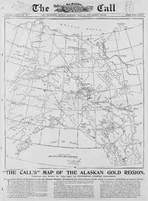
~ VOLUME SAN FRANCISCO, SUNDAY MORNING, JULY 25, 1897—THIRTY PAGES. N uvuvc;/‘\ . | Nowikakat [ hysl = \ /Q.w.,\u%:~~"” Polised¢s X A // i Y U KQ/VR W b \ 4 . 1 / 4 / Copyrighted—All rights reserved. Q| @ Fort Hom in Lcr-u Ramparts g i, P Beecher PL Q 2 C" (45 oo, - 5 i 1Sl m....:ngfi,. G 148 & G258 X =5 laing S a & ger.sz, el T | : 3000 % 4ooo Jeet: 4 't g L i, . e i S \‘ b -uh"..‘ NG 2 \ N f Vil 25 15 ~ 0 i - S5 I aoseuyme | & A w N > & . ] GRS , el S 3 Lt 1 B 4 Wty \ Soep ™ ¢ Range 7 ! e o ¢ 2 P e 13 ke?, 500 REY MY vrdngell \ N g < : A S (TN wuaRea, 2,10 600 ", “ur, ™ 1ooco * N ' maw MRSl Ty O S lloau. Rinx Rapids Fivk Finger Repide ~ L.Avkell nrt Good Hope Compiled and Dravn for ‘“The Call” by PROFESSOR GEORGE DAVIDSON. “THE CALL’S” MAP OF THE ALASKAN GOLD REGION. Amxn Accurate Chart of the HEnovwn Waters, Routes, Ranges, Settlements and Gold Fields, F'rom Coast to Interior, Including the Junecau Route. HIS map of those portions of Alaska and the Dominion 6f Canada in which public interest is centered has been prepared for THE CALL by Professor George Davidson, who has been for a generation the most competent geographer on the Pacific Coast. Alaska is in the field which for so many years he superintended as the head of the Coast and Geodetic Survey on this coast, and he has been able to supplement the best of the charts yet issued from his personal familiarity with the field and from special sources. This map is a long advance from the best maps hitherto obtain- able, and it will not be much improved upon until a long period of exploration and survey has elapsed. This map will be invaluable to those who invade the Yukon region this year and next, and it will long be a valuable reference for all in- terested in Alaska. The geographical features not charted it is impossible to chart. The latest geographical information about the interior is here given, . but years of exploration and survey must elapse before this region is mapped for any distance from the main watercourses. It includes in its showing the magnetic variation of the compass, which it is neces- sary to know in finding directions by that instrument, as many travel- ers will have occasion to do. Lines of variation five degrees apart are shown, and a-'rrows indicate mcre simply the direction in which the needle actually points—to the magnetic pole and not the North Pole. The overland route can be readily traced from Juneau to Dyea by water, thence over Chilkoot Pass to Lake Lindeman and Lake Bennett, where boats and rafts are built for the long journey of 600 miles down the watercourse to Dawson. The ride is on through Lake Marsh, through or around White Horse Rapids and to the Lewis River, thence to the Yukon, which is formed by the junction of the Lewis and Pelly at Fort Selkirk. Chilkat Pass and White Pass may be found on either side of Chilkoot Pass, and both may become important routes. = The proposed railroad is shown connecting the navigable extremes of Stahkeen River and Feslin Lake in British territory, 0