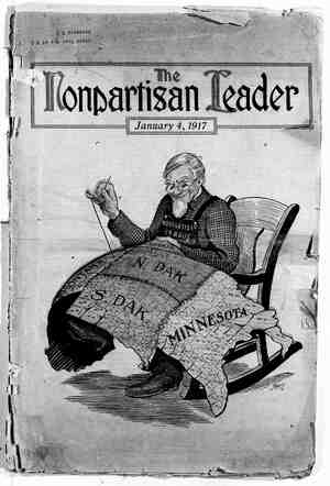
The Nonpartisan Leader Newspaper, January 4, 1917, Page 9
You have reached the hourly page view limit. Unlock higher limit to our entire archive!
Subscribers enjoy higher page view limit, downloads, and exclusive features.
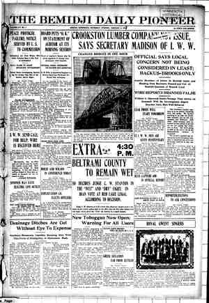

|- Red’s Floods Can Be Stopped ' Second of Two Articles Written for the Leader on the Red River | Valley’s Problem by Herbert A. Hard - R 1 A HE first of this series of articles, } in last week’s Leader, may be i cited as showing the character and increasing extent of damage from floods in the Red River valley. The causes of the recent inundations were ~ explained with their peculiar two fold problems, one relating to farming, the other to towns on the river bank. Reasons were given for the failure of the great mileage of already constructed ditches, and an account of the numerous surveys on the Minnesota side was noted. Early agitation for flood control leading up. to the recent big Tri-State: congress at Fargo was cited. This week ways and means of flood control will be given. The survey is after all only the first big step in drainage and flood protection. Three or four plans there are for pre- venting floods, one or all of which may here be used after the absolutely indis- pensable survey, and the recommanda- tion of the best engineers. (1) Dredg- ing and straightening river channel. (2) Construction of reservoirs to impound water of the tributaries of the Red. (3) Levees. (4) Drainage- mains and ditches over the entire valley, one to two miles apart. From Lake Traverse to Canadian line the Red and Bois de Sioux rivers mean- der until they measure 21 times the air line distance between those points. The slope of the valley floor to the north is one foot per mile, therefore the river fall is made less than one-half foot, due to the meanders, many of which can be: short cut; . just as Butler treated the James river in Civil war time. Three of the many Red river loops can be cut off by. 15 miles ~of canal, shortening the _..channel” 33 miles. - In other states the government has aided in straightening and dredging just such meandering streams as the Red, Sheyenne; and-Bois de Sioux. At com- paratively small cost, river loops are cut ~ off by a direct channel, leaving-the “ox- - bows”. to silt.up at the ends, forming attractive lakes—or they. may be filled with nearby excavations and make valu- able additions:of land. The remaining river channel is dredged in places, and all results in giving a swifter current which helps the river to clear itself of its sediment. In course of 25 years some rivers, with swifter current, materially lower their bed below the country level, which gradually becomes less liable to flooding. The banks of the Red and other streams in places are thickly set with underbrush and trash, caysing serious friction and impediment to the current, which chan- " nel straightening and clearing will obviate. : IMPOUNDING DAMS AND RESERVOIRS The war department has surveyed the various reservoir and canal sites in Minnesota, including Red, Traverse, Big Stone, Ottertail and Lac Qui Parle lakes.® Relative to these projects the following is taken from the “minority” engineering committee report brought in by Messrs. Hard and Sardeson at the recent Flood Control congress at Fargo, and upon which basis the organization is now work ing: “These projects have been pronounced feasible and given estimated cost of con- struction by the chief engineer. Your committee recognizes the availability of theee lnltes as reservoir sites.” Estimates on cost of reclamation pro- jects, based on the war department report plus appreciation in labor and material cost: Par lakes Traverse and - Big Stone For lakes Traverse and . Big Stone with capacity to hold flood water from $ 375,000 the Ottertail with feeder canals B i Sein - 1,250,000 For Ottertail lake and . river (separate project)........ 70,000 For Red lake and river._...... 275,000 For Lac Qui Parle and Minnesota river .....c......... 400,000 . The Red lake and Lake Traverse-Big Stone 'projects are of especial interest. The former because the lake is the larg- SKETCH MAP Y DAM ano RESERVOIR SITES \{ DIVERSION DAMSITES X CANALS PROPOSED COMPILED . BY ANITOB A 4 A AA - LINE BOUNDS AREA DRAINING INTO RED RIVER % HACHURED AREA SHOWS THE RELATIVELY: SMALL PORTION OF THE RED.RIVER VALLEY YET SURVEYED IN N.DAK. THUS NOMNE OF THE RESERVOIR SITES HAVE BEEN COVERED IN N.DAK. AS THEY HAVE IN MINNESOTA NINE. RED RIVER VALLEY HERBERT A HARD — LAy S N e e e 3y # _ @ ORTONVILLE PROPQSED CANAL : ; ; / JER ‘ LAC QuI ‘ Q‘ X ‘o“ea ‘ PARLE & | wRES S : v RED WOOD fA “J