The New York Herald Newspaper, November 29, 1875, Page 3
You have reached the hourly page view limit. Unlock higher limit to our entire archive!
Subscribers enjoy higher page view limit, downloads, and exclusive features.
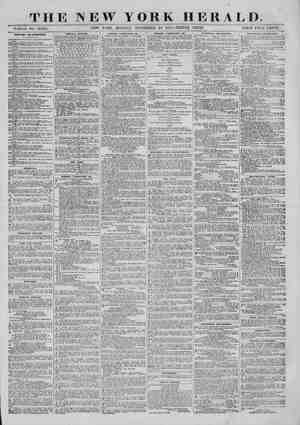
STANLEY. Progréss of the Commander of the Herald and Telegraph Ex- pedition in Africa, EXPLORATION OP THE VICTORIA NIYANZA Observations and Map Verified. Speke’s The American Explorer Travels Along the Southern Coast of the Lake in the Lady Alice, ‘At the Mouth of the Shimeeyu--- Sima and Magu, ATTACKS AND ASSAULTS BY HOSTILE NATIVES Through the Napoleon Channel to the Uganda Shore, ‘A Royal Reception---Salutes, Flags, Drums and Soldiery. King Mtesa—His Court, Guards and Personal Appearance, The American Christian Tumbles Islamism t> the Ground. By the European mail of the 19th inst., to hand yes- Jerday, we havo the following interesting letter re- porting the travels and explo.ation of Mr. Henry M. Btanley, commander of the Huxatp and Telegraph ex- pedition in Africa:— ULaGata, Mresa’s Caprrat, UGANDA, E. Low, 32 pra. 49 wun. 45 agc., N. Lat. 0 peo. 32 min., April 13, 1875, I write this letter in a hurry, as it is the mere record pf a work begun and not ended—I mean the explora- tion of the Victoria “Ntyanza. But brief as it neces- Barily must be, I am sure it will interest thousands of your readers, for it solves the groat question, ‘Is the Victoria Niyanza one lake, or does it consist of a group pf lakes?” such as Livingstone reported it tobe, In \nswer to the query, I will begin by stating that I have explored, by means of the Lady Alice, the whole of the southern, eastern and northeastern shores of the Victoria Niyanza, have penetrated into every bay, inlet mond creek that indent its shores, and have taken thir- by-sevon observations, so that I fecl competent to decide upon the question at issue, without bias or prejudice to any hypothesis. 1 have a mass of notes relating to the countries I visited, and ample means of ygoaking a proper chart at my camp at Usukuma, but I ave neither paper, parallel rules nor any instrument whatever to lay down the positions I have taken, with mo at present. I merely took an artificial horizon, pextant, chronometer, two aneroids, boiling point ap- paratus, sounding line, a few ‘guns, ammunition and Bome provisions, as I wished to make the boat as light ‘as possible, that she might work easily in the storms of the Niyanza. But when I reach camp I pronsse to raw acorrect chart of the Niyanza and yftite such potesupon the several countries I have Visited as will amply répay perusal and study, AMSUICAN BURVEY OF THE LAKE. 1 have already ifformed you that our camp at Kagebyi, in bier peop rat in longitude 33 Hog, 13 min, east and“Tatitude 2 eg. 31 min. south. Before starting on the exploration’ of the lake I ascer- tained that Muanza was gituated a few miles west, pimost on the same parallel of/ latitude as Kageby!, ‘Now Muanza is the point whence Speke ob- eerved the Victoria Niyanza and where he drew his im. aginary sketch of the lake from information given to him by the natives. If you will look at Speke’s map you will findthat it contains two islands—Ukerewo and Maziti, Looking at the same objects from Kagehyi, 1 would have concluded that they were islands myself; but taithfal exploration of the lake has proved that they are not islands, but a lengthy promontory of Jand extending from longitude 34 deg. 45/{ min. east, to longitude 32 deg. 40 min. 15 sec. east, That part of the Iake that Speke observed from Muonza ts merely a huge gulf, about twenty-five miles wile by sixty-five miles long. To the noble Lake Niyavza Speke loyally added that of Victoria, as a tribute to his Sovercign, which let no man take away; butin order to connect forever Speke’s name to the lake which he discovered I have thought it bat simple justice to the gallant explorer to call this immense gulf Speke Gulf, If you look again on Speke’s map you will observe how boldly he bas sketched the Niyanza stretching eastward and Gortheastward, Considering that he drow it from me‘e native report, which never yet was exact or clear, I must say that I do not think any other man could have arrived so near the truth, 1 must confess that I sould not have done it myself, for I could make noting of the vague and mythical re- ports of the natives of Kagehyi. AT THE MOUTH OF THE SHIMERYD. Proceeding easfward to the unknown and fabulous distance in the Lady Alice, with a picked crew of eleven men and a guids, I coasted along the southern coast of the take, round many a noble bay, until we came to the mouth of the Shimeeyu, in longitude 33 deg. 33 min, east, Jatitude 2 deg. 35 min. south—by far the noblest river that ¢mpties into the lake that we have yot seen. ‘The Shiméeyu has a length of 370 miles, and is the ox- treme séuthern source of the Nile, Before emptying into the lake it unites with the Luamberri River, whence it issues in @ majestic flood to Lake Victori Niysoza, At its mouth it isa mile wide, but contracts as ve proceed up the river to 400 yards. Even by itself {t would make no insignificant White Nile, By accident our route through Itara took us from its birth- place, a month’s march from the Jake, and ‘along many 4 milo of its crooked course, untilby means of the Lady Alice we were enabled to seo it enter the Niyanza, a ‘taver of considerable magnitude, SIMA AND MAGU. Between the mouth of the Shimeeyu and Kagehyi were two countries—Sima and Magu—of the samo aatare as Usukuma, and inhabited by peoples speaking ibe same dialect’ On the eastern side of the river is Mazanza, and beyond Manasa, SOUTHWARD TO UTUTWA. Coasting still along the southern shoro of the lake, beyond Manasa, wo come to Ututwa, inhabited by a people speaking a different language, namely, that of she Wajika, as the Wamasal are called here, a people slondor and tall, carrying formidably long knives and terrible and portentous spears, THR BXTREME END OF SPEKE GULP. Tn longitude 38 deg. 45 min. 45 sec. cast we came to the extreme end of Speke Gulf, and then turned northward as far as latitude 2 deg. 5 min, south, whence we pro- ceeded westward almost in 4 straight line along Shashi and Iranbu, in Ukerewe. In longi. tude 33 deg. 26 min, east, we came to a strait— the Rugeji Strait—which separates one-half of Ukerewe from the other half, and by which there is adirect means of communication from Speke Gulf ‘with the countries lying north of Ukerewe. We did ot pase through, but proceeded still westward, hug- ging the bold shores of that part of Ukerowe which is an feland, as far as longitude 22 deg. 40 min. 16 soc, east, whenee, following the land, we turned northwest, thence north, until in Jatitude 1 deg. 63 min, south we turned cast again. coasting along tho northern shores NEW a YORK HERALD, MONDAY, NOVEMBER 29, 1875.-TRIPLE SHEET. “THE GRAND NILE RESERVOIR Map of the Great Lake Victoria Niyanza and its Tributaries--Speke’s and Stanley’s ofUkerewo Island until we came to the tabular-topped bluff of Majita (Speke miscalled this’ Mazita, or Mazitl and termed it an island), in longitude 83 deg. 9 min. 45 sec. east, and latitude 1 deg. 50 min., south, whence the land begins to trend northward of east, North of Kashizu in Ukerewe lies the large island of Ukura, which gives its name with some natives to that part of the lake ly- ing between it and Ukerewe. It is about eighteen miles long by twelve wide, and {s inhabited by a peoplo strong in charms and magic medicine, From Majita we pass on again tothe north shore of Shashi, whose south coast is bounded by Speke Gulf, and beyond Shashi we come to the first district in Urari. IN URURI, Ururi extends from Shashi in latitude 1 deg, 50 min, south, to latitude 0 dog. 40 min, 0 sec, south, and embraces the districts of Wyo, Irien|, Urieri, Igengi, Kutirl, Shiratt and Moharuv. Its coast is indented most remarkably with bays and creeks, which extend far inland. East of the immediate coast line the country is a level plain, which is drained by an important river called Shirati, All other streams which issue into the lake along the coast of Ururi aro insignificant, North of Shirati, the most northern district of Ururi, begins the country of Ugeyeya, whose bold and moun- tainous shores form a strong contrast to the flats of Shirgti and Molurau. Here are mountains rising abruptly from the lake to a height of 8,000 feet and more. This coast is also very crooked and irregular, requiring patient and laborious rowing to investigate its many bends and curves. The people are atimid and suspicious race, much vexed by their neighbors, the Warari, south, and Wamasui, east, and are loath to talk to strangers, as the Arab slave dealers of Pangani have not taught them to love people carrying guns, The Wageyeya, having been troubled by the Waruri, have left many miles of wilderness between their coun- try and that of their flerce neighbors uninhabited. But Sungoro, the agent of Mse Saba, who prompted the ‘Waruri to many a devilish act, and has purchased the human spoils, is constructing In Ukerewe a dhow of twenty or thirty tons burden, with which he intends to prosecute more actively his nefarious trade, Nothing would have pleased me better than to have been com- missioned by some government to hang all euch wretches wherever found; and, if ever a pirate deserved death for inhuman crimes, Sungoro, the slave trader, deserves death. Kagehy!, in Usukuma, has become the seat of the inhuman slave trade. To this part they are collected from Sima, Magu, Ukerewe, Ururi and Uge- yoya; and when Sungoro has floated his dhow and hoisted his blood-stained ensign the great sin will in- crease tenfold, and the caravan road to Unyanyembe ‘will become heil’s highway. On the coast of Ugeyoya I oxpected to discover a channel to another lake, as there might be a grain of truth in what the Wanguana reported to tLivingstone; but I found nothing of the sort, except unusually deep bends in the shore, which led nowhere, The streams were insignificant and undeserving the name ot rivers. ISLANDS AT TIE EQUATOR, A few miles from the Equator 1 discovered two islands formed of basaltic rock and overgrown with a dense growth of tropical vegetation. One had a ural bridge of rock thirty feet long and fifteen wide; the other hada small cave, In longitude 34 deg, 49 min, east, at Nakidimo, Uge- yeya, we came to the furthest point cast of the Vic- toria Niyanza, ot BARINGO, North of Ugeyeya begins Baringo, s small country, extending over about fifteen miles of Jatitude, Jie canst Lines of Exploration. belle: e foro’s Battle KARIO~ — , efond 5 LY sii. ~~ Chaytasimbay, py 3.575 FT. ABOVE THE SEA is algo remarkable for deep indentations and noble bays, some of which are almost entirely closed by land and might well be called lakes by uncultivated Wanguana. Large islands are also numeroas, some of which lie 80 close to the mainland that if we had not hugged its shore closely wo should have mistaken them for por- tions of the mainland. North of Baringo the land is again distinguished by lofty hills, cones and plateaus “which sink eastward into plains, and here a new coun- try commences—Unyara, the language of whose pedple is totally distinct from that of Usukuma, and approaches to that of Uganda and Usoga. THE POPULATION. Unyara occupies the northeastern coast of the Victo- ria ‘Niyanza, and by observation the extreme north- eastern point of the Niyanza ends in longitude 84 «deg. 35 min, cast and Jatitude 83 min, 43 sec. north, As I intend to send you a chart of the Niyanza, it {s needless here to entor {nto'minor details, but I may as well mention here that a large portion of the northeastern end of the lake is almost entirely closed in by the shores of Ugana and of two islands, Chaga and Usugura, the latter of which {s one of the largest in the Niyanza. THE GROGRAPHICAL SITUATION. ‘While Unyara occupies the northeastern coast of the Niyanza, Ugana commences the northern coast of the Inke from the east, and, running southwest a few miles, forms here a large bay. It then trends westward, and the island of Chaga runs directly north and south for eight miles ata distance of twelve miles from the op- posite coast of Unyara, With buta narrow channel be. tween, Usuguru Island rons from the southern extrem- ity of Chaga, in a south-southeasterly direction, to within six miles from the eastern shore of the main- land, Thus almost a lake is formed separate from the Niyanza, North of Ohaga Island Usoga begins with tho large district ot Usowa, where we met with the first hostile intention—though not act, as the act was checked by show of superior weapons—on the part of the natives, Thence, as wo proceed westward, the districts of Ugamba, Uvira, Usamu and Utamba line the coast of Usoga, Where Utamba begins, large Islands again become frequent, the principal of which is Uvuma, an indo- pendent country and the largest im the Victoria Niyanza, FIRST ATTACK BY NATIVES, At Uvyuma we experienced treachery and hostility on the part of the natives. By show of friendship on their part we were induced to sail within a few yards of the shore, while a mass of natives were hid in am- bush behind the trees, While eailing quietly by, ex- changing friendly greetings with them, we were sud- denly attacked with a shower of large rocks, several of which struck the boat; but the heim being quickly put ‘hard up,’’ we sheered from shore to a safer dis- tance, but not before one of the rascals was laid dead by a shot from one of my revolvers, After proceeding some miles we entered s channel between the islands of Uvuma and Bugeyeya, but close to the shore of Uvuma Here we discovered a fleet of large canoes—thirteen in number—carrying over a ! hundred warriors, armed with shiefds and spears and sling, The foremost canoe contained baskets of aweet potatoes, which the people held upas if they were desirous to trade, I ordered my people to coase row- ing, and as there was but @ slight breoze wo still held on with the sail and permitted the canoe to approach, SRCOND. ATTACK, While we were bargaining for potatoes with this canoe the other canoaa came up and blocked the boat, EQUATOR \ Dke is A while the people began to lay hands on everything; but we found their purpose out, and I warned the canoes away with my gun. They jeered at this and immediately seized their spears and shields, while one canoe hastened away with some beads they had stolen, and which a man insolently held up to my view, and invited us to catch him. Atsight of this I fired, and the man fell dead in his canoe, The others prepared to launch their spears, but the repeating rifle was too much for the crowd of warriors who had hastened like Pirates to rob us. Three were shot dead, and as they retreated my elephant rifle smashed their canoes, the result of which we saw int the confusion attend- ingeach shot, After a fow shots from the big gun we continued on our way, still bugging the shore of Uvuma, for it was unnecessary to fly after such an ex- hibition of inglorious conduct on the part of thirteen canoes, containing in the aggregate over one hundred men. 3 In the evening we anchored in the channel between Uvuma and Usoga, in east long. 33 dog, 40 min, 15 sec., and north lat. 0 deg. 30 min. 9 soc, NAPOLEON CHANNEL—THE CURRENT. Next morning, the current perceptibly growing stronger as we advanced north, we entered the Napo- leon Channel that separates Usoga from Uganda, and then sailed across to the Uganda shore, Having ar- rived close to the land, we pulled down sail and rowed towards the Ripon Falls, the noise of whose rushing waters sounded loud and clear in our ears, Tho lake shoaled rapidly, and we halted to survey the scene at @ spot half a mile from tho first mass of foam caused by tho escaping waters. Speke has been most accurate in his description of the outfowing river, and his pencil has done fair jus- tice to it The scenery around, on the Usoga and the Uganda side, has nothing of the sublime about It, but {it is picturesque and well worthy avisit, A few small islands dot the channel and lie close ashore; while at the emtrance of the main channel, looking south, the large islands of Uziri and Wanzi stretch ob- Iiquely, or southwest, toward Uvuma But the eyo of the observer is more fascinated by the ranks of swelling foam and leaping waters than by the uneven contour of the land; and the ear is attracted by tho rough music of thoir play, despite the terrors which the imagination paints to us, and it absorbs all our attention to watch the smooth, flowing surface of the lake, suddenly broken by the rocks of gneiss and hematite which protrude, white and ruddy, above the water, and which threaten instant doom to the unlucky navigator who would be drifted among them, There is a charm in the scone that belongs to few such, for this outfowing river, which the Great Victoria Niyanzadischarges from its bosom, becomes known to the world as the White Nile, Though born amid the mountains of Itura, Kargue and Ugeyeya it emorges from the womb of the Niyanza the perfect Nile which annually resuscitates parched Egypt. From the Ripon Falls we proceeded along the coast of [kira southwest until, gaining the shore opposite Uzirl, we coasted westerly along the irregular shore of Uganda, GUIDES OnTAINED, Arriving at the isle of Kriva we secared guides, who voluntarily offered to conduct us as far as Mtosa’s cap- ital, A MESSAGE TO KING MTESA. Halting # short time at the island of Kibibi, we pro- ceeded to Ukafu, where a snug horseshee-shaped bay was discovered, From Ukafu we despatched mossen. gers to Mtesa to announce the arrival of a white vis- itor in Uganda, after being most hospitably received y? Kasirondo Kamasia Head waters of with fair words but with empty hands along the coast of Uganda, CORRECTION OF THE MAPS, 1 was anxious to discover the entrance of the Lua- Jerri, and questioned the natives long and frequently abont it, until, securing an interpreter who understood the Kisawahili, we ascertained that there was no such river as the Laujerri, that Lauserri meant still water, applicable to any of the many lengthy creeks or narrow inlets which indent the coasts of Uganda and Usoga, from which I conclude that Speke was misinformed, and that his ‘‘Luajerri” is Luaserri, or still water. At least, we discovered no such river, either sluggish or quick, flowing northwards; while in the neighborhood of “Murchison Creek” I did discover a long and crooked {nlet called Mwrau—a Luaserri, or still water— which penotrated several miles inland, the termination of which wo saw, I noticed a positive tide here during the morning. Fortwo hours the water of this creek flowed north, subsequently for two hours it flowed south, and on asking the people {f {t wore a usual sight they said {t was, and was visible in all of the inlets on the coast of Uganda, ROYAL RAVAL WELCOME, Arriving at Beya, we were welcomed by a fleet of canoes sent by Mtesa to conduct us to Murchison Creek. On the 4th of April I landed amid a concourse of 2,000 people, who saluted me with a deafening volley of musketry and waving of flags. Katakiro, the chief Mukungu, or officer in Uganda, then conducted me to comfortable quarters, to wnich shortly afterward were brought sixteen goats, ten oxen, an immense quantity of bananas, plantains, sweet potatoes, besides eggs, chickens, milk, rice, ghee and butter. After such a royaland bountiful gift I fels more curiosity than ever to see the generous monarch. MTESA’S RECEPTION, In the afternoon Mtosa, having prepared beforehand for my reception, sent to say that he was ready to receive me. Issuing out of my quarters I found my- self in a broad street eighty feet wide and half a mile long, which was lined by his personal guards and attendants, his captains and their respective retinues, to the number of about 3,000, At the extreme end of this street and fronting it was the King’s audience house, in whose shadow I saw dimly the figure of tho King eftting in a chair, As I advanced toward him the soldiers continued to fire their guns, The drums, sixteen in number, beat a fearful tempest of sound, and the flags waved, until I became conscious that all this display was far beyond my merits, and consequently felt greatly embarrassed by so flattering a reception. Arrived before the audi- ence house the King rose—a tall and slonder figure, dressed in Arab costume—approached me a few paces, held out his hand mately, while the drums continued their terrible noise, and we stood silently gazing at each other a few mioutes, I, indeed, more embarrassed than ever. Bat soon, relieved from the oppressive noise of the huge drams and violence of the many screaming, discordant fifes, I was invited to sit, Mtesa first showing the example, followed by his great cap- tains, about one hundred in number, HIS PERSONAL APPEARANCE, More at ease, I surveyed the figuro and features of this powerful monarch, Mtesa is about thirty-four years old, and tall and slender in build, as 1 have @ ready stated, but with broad shoulders, His face is very agreeable and pleasant, and indicates intolligence and mildness, His eyes are largo, his nose and mouth are a great improvement apon those of the common type of negra. and approach to that of the Muscat Arab 3 His teeth are splen~ Slightly tainted with negro did, and gleaming white. MAXNER OF ADDRESS. As s00n as Mtesa began to speak I became captivated by bis manner, for there was much of the polish of a true gentleman about it—it was at once amiable, grace- ful and friendly, It assured me that in Mtesa f bad found @ friend, a generous King, and an intelligent ruler, He is infinitely superior to Seyd Burghasb, the Arab Sultan of Zanzibar, and he appears to‘ me like @ colored gentleman who has visited: European courts, whence he has caught a certain polish and ease of manner and « vast amount of information which be has collected for the improve- ment of his race. If you will recollect that Mtesa is a native of Centrai Africa, and that he had seen but three white men until I came, you will, perhaps, be as much astonished at this as Iwas. And if you will but think of the enormous extent of country he rules, extending from east longitude 34 to east longitude 31, and from north latitude 1 to south latitude 430, you will perceive the immense influence he could wield toward the civilization of Africa. Indeed, 1 could not regard this King or look at him in any other light than the Augustus by whose means the light of the Gospel wil! be brought to benighted Middle Africa, Undoubtedly the Mesa of to-day is vastly superior to the vain youth whom Speke and Grant saw. There is no butchery of men or women; seldom one suffers the extrome punishment. Speke and Grant left bim a raw, vain youth, andabeathen. He is now a gentleman, and, professing Islamism, submits to other laws than his own erratic will, which, we are told, led to severe 4nd fatal consequences. All his captains and chief offi- cere profess the same creed, dress in Arab costume and in other ways affect Arab custom, He hag a guard of 200 men—renegadves from Baker’s Expedition, Zanzi- bar defalcators, a few Omani and the elect of Uganda, ms cour, Behind his throne, an armchair of native manufac- ture, the royal shieldbearers, lancebearers and gun- bearers stand erect and staid, On either side of him are his grand chiefs and courtiers, sons of governors of his provinces, chiefe of districts, &. Outside the au- dience house the lengthy lines of warriors begin with the chief drummer and the noisy goma beaters. Next come the screaming fifers, the flag and banuer bearers, the fusiliers, aud so on seemingly ad i/initum with spearmen. GAYETY AND REJOICING, Mtesa asked a number of questions about various ble thereby showing a vast amount of curiosity and great fntelligence. The King had arrived at this camp—Usavara—four- teen days before my arrival, with this immense army of followers, for the purpose of shooting birds, He now proposed to return, after two or three days’ rest, to hys capital at Ulagalla, or Uragara. Each day of my stay at Usavara wasa scene of gayety and rejoicing, On the first after my arrival we behela a grand naval review—eighty-four canoes, each manned by from thirty to forty men, containing in the aggregate a force of about 2,500 men. We had excellent races and wit- nessed various manwuvres by water. Each Admiral vied with the other in extolling aloud the glory of their monarch, or in exciting admiration from the hundreds of apectators on shore, Tho King’s 300 wives were present en grande tenue, and were not the least impor- tant of those on shore. OUTDOOR SPORT, The second day the King led his fleet in person to show me his prowess in shooting birds. We rowed, or wore rather paddied, up ‘Murchison Creek,’’ visiting: en route a dhow he is building for the navigation of the jake, his place of residence, and his former capital, Banda, where Speke and Grant found btm. HINTS POR THR: GROGRAPHERS. En passant, 1 may remark that Speke could not pos- sibly have seen the whole of the immense bay he has denominated creek. It is true thatfrom a short dis- tance west of Dwaga, his Ramazan palace, up to Mngono, the extremity of the bay,’ a distance of about eight miles, it might be termed a creek, ‘but this distance does not approach: to one-half of the bay. 1 respectfully request’ geographors, Messrs. Keith, Johnston and Stanford especially, tochango the name of Murchison Creek to Murchison Bay, as more worthy the large area of water now known by the for- mer inappreciative title, Murchison Bay extends from: north latitude 15 deg. to north latitude 27 deg., and from east longitude 32 deg. 53 mm. to 82 deg. 38 min. in extreme length. At the mouth the bay contracts toa width of four miles, but within its greatest breadth is twolve miles, Surely such a body of wator—as terms .go—deserves the more appropriate name of bay, but I leave it to fair judging geographers to decide. For the position of Mtesa’s capital Ihave taken three observa- tions, three different days. My longitude agrees pretty closely with ‘tliat of Speke’s, while there is but four miles’ diferente of latitude. THE ARMY. The third day the troops of Mtesa were exercised at target practice, and on the fourth day we all marched for the Grand Capital, the Kibuga of Uganda, Ulagalla or Uragara, MTBSA IS A GREAT KING, He isa monarch who would delight the soul of any intelligent European, as he would see in Mtesa the hope of Central Africa. He is King of Karagwo, Uganda, Unyoro, Usoga and Usui. Each ‘day I saw something which increased my esteem and respect for him. He is fond of imitating Europeans and great kings, which trait, with a little tuition, would be of immense benefit to his country. Ho has prepared broad highways fa the neighborhood of his capital for the good time that is coming when some charitable European will send him any kind of a wheeled vehicle. As we approached the capital the highway from Usavara increased in width from 20 feet to 150 feet’ When we arrived at this magnificent breadth we viewed the capital crown: ing an eminence commanding a most extensive view of a picturesque and rich country teeming with gardeng of plantains and bananas, and beautiful pasture land. Of course huts, however large, lend but little attraction to a scene, but a tall fagstaif and an immense flag proved a feature in the landscape, IN THE CAPITAL. Arrived at the capital I found that the vast collection of huts crowning the eminence were the Royal Quar- ters, around which ran five several palisades and cireu- lar courts, between which and the city was a circular road, ranging from 100 to 200 feet in width, from which radiated six or seyen magnificent avenues, jined with gardens and huts, AT THE PALACE IN STATE. The next day after arrival I was introduced to the Royal Palace In great state. Nono of the primitive scenes visible in Speke’s book were visible here. Tho guards, clothed in white cotton drosses, were by no means comical. The chiefs were very respectable look- ing people, dressed richly in the Arab costuine. The palice was & hugo and lofty stracture, well built of grass and cane, while tall trunks of trees upheld the roof, which was covered with cloth sheeting inside, ‘THR EGYPTIAN ENVOY, On the fourth day after my arrival news came that another white man was approaching the capital from the direction of Unyoro, and on the fifth day I had the extreme pleasure of greeting Colonel Linant de Belle- fonds, of the Egyptian service, who had been de- spatched by Colonel Gordon to Mtesa, to make a treaty of commerce between him and the Egyptian govern- ment. Tho meeting, though not so exciting as my former meeting with the venerable David Livingstone, ‘at Cjyi, in November, 1871, still may be sald to be sin. gular and fortunate for all concerned. In Colonel Bello- fonds I met @ gentleman extremely well informed, energetic and a great traveller. His knowledge of the countries between Uganda and Khartoum was most minate ana accurate, from which I conclade that but little of the geography of Central Africa be- tween the cataracts of the Nile and Uganda is unknown, To which store of valuable geographical acquisitions must now be added my exploration of the Nile sources, which pour into the Niyanza and the new countries I have visited between the Niyanza and the Unyanyembe road. In Colonel Bollefonds 1 also per- cerved great good fortune, for I now had the means to despatch my reports Of jgeographical discoveries and my long delayed letters, THE FUTURE ‘The day after to-morrow I intend to return to Usu- kuma, pfosecuting my geographical researches along the western shore of the Victoria Niyanza. After which I propose to match the expedition to the Ka- tonga Valley, and thence, after another visit to Mtesa, march directly west for Lake Albert Niyanza, where I hope to meet with some more of the gallant subordi- nates of Colotiel Gordon, by whom I shall be able, through their courtesy, to send several moro letters descriptive of discoveries and adventures, I might protract this letter mdefinitely by dwelling ‘upon the value of the service rendered to science and