The New York Herald Newspaper, November 29, 1869, Page 3
You have reached the hourly page view limit. Unlock higher limit to our entire archive!
Subscribers enjoy higher page view limit, downloads, and exclusive features.
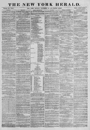
INTEROCEANIC COMMUNICATION, An Expedition Fitting Cut to Sur- History of Efforts and Projects to Connect - the Atlantic and Pacific Oceans. Explorations from the Time of Columbus to the Present Day. Interesting Details Regarding Proposed Routes. PURPOSE OF THE PRESENT UNDERTAKING The United States to Construct and Control the Canal. @he Treaty Between the United States and the Colombian Government=President Grant the Author of the Project—His Desire to Make It a Saccess—A Surveying Party to be Sent to the Isthmus—Prospect of the Ratification of the Treaty. WASHINGTON, Nov. 28, 1869, The construction of a ship canal across the Isth- Tous of Darien 1s one of the great results which Pres- ident Grant hopes to accomplish during his admin- istration. It 18 not, perhaps, generally known that Grant ls entitled to the credit of having suggested to our government the propriety of negotiating the Darien Ship Canal treaty with the United States of Colombia. It appears that he has given much atten- tion to the subject and is thoroughly acquainted with it in all ite aspects, During the admin- istration of Andrew Johnson he called the attention of Mr. Seward to the importance of our getting con- trol of the isthmus, with the view of construcung a ship canal from the Atlantic wo the Pacific. Mr. Seward himself was alive to the importance of the matter, but was at a loss to know how to get about it. General Grant suggested that some approach should be made to the Colombian government so as to get a treaty out of it, granting the right of way across the isthmus. Mr. Seward adopted tne sug- gestion and communicated with General Salgar, then Colombian Minister to this country, on the subject. He in turn communicated with his government, and the result was thatthe draft of a treaty was pre- pared by General Santos Acosta, then President of the United States of Colombia, and now Minister to the United States, This draft was sent to Mr. Seward, who made some amendments to it, after which it was returned to. the Colombian govern- ment, From this the treaty sent to the Senate last February was drawn up and negouated by General Cushing and Peter J. Sullivan on the partof the United States, All through these various stages it appears that General Grant took a deep interest In the project, and lost no occasion to urge it forward. ‘The fact that the Senate of Colombia refused to Tatify the treaty, and that it has not been acted on by the United States Senate, is not regarded as evi- dence of its failure. The President still hopes that it will be ratified by both governments within the ume prescribed by the treaty itself—viz., September, 1870, It is understood that the hitch in the Colombian Senate arose from a desire on tho part of the Colom- Dian government to get a few hundred thousand dol- Jars from our government for what the Colombians conceive to be of immense value to us. Strangely enough they do not seem to understand that the canal when constructed will also be beneficial to them. But those who are familiar with the whole subject are of opinion that tf necessary it would be Detter for our government to pay the Columbians something than to allow the proposed work to be done by the English or French and to come under the contro) of those nations after it shall have been finished. The Colombian Senate mects again in January, and should it manifest a disposition to per- sist in its refusal to ratify the treaty it is probabie President Grant will make a recommendation to Congress suggesting that the’ diiiculty in the way beremoved by making an appropriation which will satisfy the impecunious Colombians. There was no opposition to the treaty worth speaking of developed in our Senate last winter. It would probably have been ratified but for the fact that our government ‘was anxious that the Colombian Senate should act first, It may be that the treaty will have to become the subject of further negotiations between the two governments, but there is good reason to believe that it will finally be agreed upon and ratifications exchanged, even if our government should be com- pelled to make what may appear to some large con- cessions to the Colombians. In the meantime the Colombian government has given our government permission to send a force to the isthmus to examine and locate a survey for the most practicable route for a canal that will connect the waters of the Pa- Cific with those of the Atiantic. President Grant, whose interest in the project has only increased ‘with bis elevation to the Presidency, is deter- Mined to use all the means at his command to farther théPundertaking. He has accordingly directed the Secretary of the Navy to detail a sumi- cient force to make the necessary surveys and select the best route. For this work the Secretary of the Navy has detailed the Nipsic, Commander Selfridge, and the Guard, now being fitied out at New York, ‘These vessels will take out several oficers belonging to the Coast Survey to assist in the work. The whole matter will be placed under the superintend- ence of Rear Admiral Davis. Admiral Davis 1s especially adapted to the work, being familiar with the isthmus aud with the several routes heretofore proposed fora ship canal. It will be remembered ‘shat in March, 1806, the Senate passed the following resolution:— Resolved, That the Secretary of the Navy furnish, through @ report of the Superintendent of the Naval Observatory, the summit level and distance by sur- vey of the various proposed lines for interoceanic canals and railroads between the waters of the Atlantic and Pacitic oceans; as also their relative merita as practicable linea for the construction of & = canal, and especially as relates to Honduras, ‘Tehuantepec, ‘agua, Panama and Atrato lines, and also whether, in the opinion of tue Superintena- ent, the Isthmus of Darien bas been satisfactorily explored; and if so, furnish in detail charts, plans, lines of levels and all information connected there- ‘with and upon whai authority they are based. In reply to this resolution, on the 12th of July, 1966, Admiral Davis submitted a report, through the Secretary of the Navy, which exhausted the whole subject and contathed all the information then known relative to & ship canal across the isthmus, ‘The facts and conclusions set forth in this report ‘Will be of great service to the surveying party which ‘will soon leave for the isthmus, In concluding his report Admiral Davis says:— It 19 to the Isthmus of Darien that we are first to ook for the soiution of the great problem of an interoceanic canal, We know enough of the inte- rior to} hy to adopt the view of Dr. Cullen, that if we leave the Indian trail, which always passes over the highest ground, and explore the country ly Age the ordinary line of travel, we shall re, id @ valley transversely dividing tne rdilieras, or at least a lower ridge than any yet surveyed. Our most trustworthy engineers in these regions, Trautwine, Michler, Prevost, McDou- gall and others, teil us that it is impossible, from the Very limited inapection of the country taken on the Indian line of travel, to form any conception of the nature of th vicinity. @ ground, even in the immediate It is unnecessary to say that the surveying party going out on the Nipsic and Guard will make a thorough exploration of ali this region of country. For the first time a survey ts to be made with the ‘View of actually constructing the long talked of ship canal, Surveying parties who have visited the isthmus heretofore were either sent out by private parties or by the government for the purpose of ob taining information, 1% may almost be considered & Axed fact that the ship canal wii De constructed, NEW YORK HERALD, MONDAY, NOVEMBER 29, 1869.—-TRIPLE SHEET. UNITING THE ATLANTIC AND PACIFIC. . vey the Isthmus of Darien. |Map Showing Proposed Routes for a Ship Canal Across the Isthmus of Darien. ‘ON ROI AM : Een GULIF ORLER\, B [APPALACHig, i= RAS OUTH OFTHE === WSSISSIPPS. Ba OF C | TEHUANTEPEC! ad — ia NGITUDE 90 FROM wRurankesee EQUATOR GREENWICH — WEST 4 oO £8T 3| LONGITUDE FROM WASHINGTON - EAST 7 SORMILLE, [=H alo and that, too,. while the present administration 1s in Power, 1118 peculiarly fortunate for the enterprise that the person who is now President not only taxes an Interzst in it, butis its most zealous advocate. Fully appreciating its vommercial importance to the United States, he is devermjned, if possible, to make the Darien Ship Canal to the New Werld what the Suez Canal will be to the Old World. HISTORY OF THE PROJECT. Efforts of the Spaniards to Discover a Pas- sage Through the Isthmus of Darien—Pro- jects to Construct a Ship Canal—Proposi- tions of President Adams to Take Possession of the Isthmus—Explorations in Modern Days—Plans of Explorers, and Surveyors— Political and Commer Effeet of a Canal Upon the United Statee—Our Commerce with the Pacific Nations and the East—Luterest« ing and Instructive Facts. “Better late than never,” though almost inexcus- ably late, and wholly culpable in neglecting oppor- tunities which would have made the construction of the Suez Canal an impossibility, we find ourselves on the verge of performing a work conceived of cen- turies ago, while yet the discoverer of America was alive and a king of Spain ruled the destiaies of the whole continent. SOLVING THE PROBLEM OF CENTURIES. The announcement that the Unived States steamer Nipsic has been ordered to convey the gavernment oficiais appointed to survey “the most direct route across the Isthmus of Darien for the proposed ship canal, provided for by the treaty between the United States and the Colombian government,” ts one preg- nant with promise, And the order itself differs ma- tertally in character from the order that sent Strain upon his unfortunate expedition, and from that which gave to Michler reputation, without pro- ducing any resulta whatever, either for the commercial good of the world or for the glory and direct commercial benefit of the’ United States. At the present moment the people of this country are not deep in the consideration of questions affecting the social and political status of the negro. The public mind is tranquil and ready for the ardent reception of schemes which will tend to develop the commerce of the republic. It would, indeed, bes deplorable prospect for our future tf, after a flerce struggie of thirty years, culminating in @ bloody and devastating war, the masses were un- willing to place partisan politics in the backgrouna, and in its place to substitute science, the triumphs of which exceed in magnitude the most signal of politi- cal or battle victories and the le of which rests upon the surest and most enduring of foundations, Tt must, even at thig early day, be considered with astonishment that the United States should have neglected to unite the Atlantic and Pacific oceans, by meana Of a ship canal across the isthmus con- necting North and South America, when proposi+ tlons looking to such an end were made, as we shall hereafter show, during the administration of Presi. dent Adams, ‘The opinion to which Strabo was inclined that a strait would be opened some day through the Isth- mus of Suez, by the action of the sea, never became aventy. We have lived to see the Mediterranean and Red Seas united, not by the work of nature, but by the science of man. No such opinion as that entertained by the great Greek geographer could be held regarding the Isthmus of Darien, As Humboldt wisely observes nothing short of the most terrible convulsion of the earth could rend in twain the lofty Cordilleras of Central America and enable the waters of the two oceans to meet in fraternal embrace. Mysterious as are the workings of nature, itcan be safely asserted, even while admitting ite possibility, that such @ convulsion 1a not likely to coconut, Reduced to the alternatives of never noasessing a short route to the Last, or of constructing one, it is gratifying to Know that we have accepted the last after many years of unnecessary dallying. Possessed of every advantage it will be our fault if the Darien Ship Canal does not exceed in importance the one recently completed in Egypt. Ample means are at our disposal; the vory elements combing to make this route tne best, the safest and the cheapest for the transit of vessels. Thus it is most likely that the dream of Columbus will be realized, and that the great highway to the Indies will be by way of the continent he discovered. Thus, too, the problem of centuries will be solved. A VISION PASSING INTO REALITY. During the last voyage of Columbus, in 1502, the Isthmus of Darien was discovered, but the great navigator went back to Spain and died without see- ing the Pacific. On the 25th of September, 1513, Vasco Nunez Balboa discovered this ocean, the placid, gentle waters of which, no less than the grand scenery of the mountain coast, touched with asentiment of admiring awe the bosoms of even the Tude adventurers who accompanied him. Yor moment all thoughts of the gold they sought van- ished from their minds as, wrapt in contemplation, they silently gazed upon the scene. It must have been a sublime moment, one never to be effaced from memory. But to Spain romance was of secondary value. The factof the land forming an isthmus led to the conclusion that there must be some connection between the oceans, which, once discovered, changed the visions of Columbus into reality. Accordingly, in 1515, Juan Dias de Solis was ordered to search for, find and pass through the straits supposed to exist. His efforts were fruitless; in fact, it is doubtful if they were very energetic. Four years passed away, during which the Spanish government kept up a constant corres- pondence with its oficials in America onthe sub- ject of this passage. The first scientific examina- tions were made early in the century by Antonio Cramer and Miguel del Corral, who found many rivers and lofty mountains, covered by dense forests in- habited by Indians; but nowhere could they find the desired passage. In 1519 Cortez conquered Mexico. Soon after he began making inquiries regarding the isthmus, and believing that the secret of its exist- ence was known to Montezuma, questioned nim re- garding it. The Aztec Emperor denied all knowleage of it, but (it {s variously stated and denied) admitted that the traditions of his people referred vaguely to @ connection between the oceans. He, however, fur- nished Cortez with charts of the coast, embracing the Hoasacoalco river, which empties into the At- lantic, on the isthmus of Tehuantepec. This locality waa afterwards named by Humboldt for a canal, which he thought could be made “between the sources of the Rio Chinalapa, which falls into the Pacific, and the Rio del Passo, which falls into the Goasacoalco (Hoasacoalco evidently), which empties into the Atlantic.” ‘ Even at this early date the Spaniards became of the opinion that there was no natural passage; for when Cortez forwarded to Charies V, the cnarts re- ferred to he reported that the isthmus was narrow, and expressed the opinion that a canal could be built from ocean to ocean by the same route that Humpoldt wrote of, as given above. About the same time the Spantards erected extensive works on Tehuantepec, which were subsequently destroyed. For over a quarter of a century the subject inte- rested the Spanish Court, and numerous propositions Wore made, most of which were chimerical, while a few possessed elements of practicability. Im 1551 Lopez de Gomaro, author of a history of the Indies, proposed constructing ship canals across the isth- mus of Tehuantepec and at Nicaragua and at Chagres, Five years after Charles V. abdicated the throne and was succeeded vy his son, Philip If, This monarch wi too busily employed by lils fruitiess wars with other nations of Europe to pay attention tosuch matters, He did indeed commission and send out two Flemish engineers to make a survey of the isthmus and locate a route for acanal. They reported having encountered so many and insur- mountable obstacles that, in their opinion, the pro- ject was impracticable, Influenced by thelr report, the Council of India represented to the King the dan- gers which Would beset the monarchy if explor: tions «were permitted on the isthmus. Philip accordingly iesued a decree forbidding all surveys and explorations in thefuture, Antonio de Alcedo, who wrote a historical work on the West Indies, which was published iu Madrid in 1786 and subse- quently “suppressed by the Spauish government on eeBoGcoTa account of the information it might give to foreign Powers,” gives this fact, and furthermore says that the navigation of the Rio San Miguel (Savana), the Atiato and of otner rivers was prohibited on pain of death, It is, therefore, not surprising that years passed without any vigorous or well directed effort being made to establish communicaticn between the two continents. It is true that the Count of Revillagigedo, one of the most,energetic of Spanish viceroys of Mexico, did pay some attention to a canal projected across the isthmus of Tehuantepec, but nothing came therefrom. But the investigations had not been confined to a single locality before the arbitrary act of the Spanish King put an end to them. What is now known as the Nicaragua route had attractea attention at an early period, which we are assured of from the fact that “old maps point out a commu- nication by water as existing actoss the isthmus from the lake to the great ocean. Other maps, somewhat newer, represent a river, under the name of Rio Partido, which gives one of its branches to the Pacific Ocean and the other to the lake of Nica- ragua,”? Acentury passed away inertly. War was waged between England and Spain; swarms of buccaneers crowded the Caribbean Sea, rumors of the vast wealth of Central and South America attracting them there- to, Jamaica was conquered, and from Port Royal har- vor bold adventurera, who were nothing less than pirates, sailed forth to prey upon the Spanish colo- nies, In 1680 Dampier, at the head of his despera- does, crossed over to the Isthmus from his rendez- vous on Golden Island, and marched into the interior in search of gold. Guided by Indians he reached a river which they told him led into the South Sea Pacific Ocean), Surgeon Lionel Wafer, who accom- panied the buccaneers on this expedition, was com- pelled to cross the {sthmus some time later. The record ne has left of his trip is most interesting. It had been stated that from a certaiu pomt on the Cordilleras both oceans could be seen, He admits not having seen this spectacle but speaks of a great depression of the mountain range, so depressed that they are mere hills separated from one another by valleys, Which allow free course for the passage of the numerous rivers. Alarmed at the boldness of the buccaneers the Spanish monarch issued a decree in 1685 closing by destruction the gold mines of Darten, in the vicinity of rivers, “because the covet- ing of them has induced the pirates to undertake the transit from the sea of the north to the sea of the south, by these rivers, to the prejudice of the public cause.’ AN INTERREGNUM AND AN OPPORTUNITY LOST. Perhaps the term “interregnum” 1s not applicable, but none other thought of at the moment expresses with sufficient significance the changes which the lapse of another century Wrought, It was really a period of time between two governments. An Angio-Saxon empire bad been established in the New World by Great Britain, whose rule had given way before the sturdy blows of American patriots, ‘thus 1685 saw colonies, vast in size and replete with unde- veloped resources, under the sway of an island in the German Ocean, and 1786 found them thirteen inae- pendent States, known to the world as the republic of she United States. 1t must not be imagined that during these one hundred years absolutely nothing was done towards finding or constructing a passage between the two oceans. We have the account of an expedition numbering 300 men, under Carrera, sent by Don Arisa to discover a passage, It failed miserably; but Adjutant Milla, a Spanish ofticer, crossed once. It is shown that he left the Savana fiver at Principe, moving directiy across the country, ascending the ravines of the Corditieras to the head- Waters of the Sucubti, thence down the sinuous Ohuquanaque to the ocean. It Was proposed by en- gineers to the court at Madrid to use the river Chagrea as the medium of communication and a canal was projected trom Verta de Cruces to Havana. But Spain was no longer the great power she once had been. True, she still was the mistross of Mexico, all of Central and the greater part of South America, Her material strength, however, had been wasted in worse than insane Wara in Europe ana in revolutions at home. The record of her deeds is, therefore, a blank. Portugal bad made some efforia, but with- out success, and Great Britain was at war witb France and her American colonies a8 well as with other Powers during a great part of the century. During the latter part of the eighteenth century the Spanish Americans became restive under the rule of the mother country. Some time in 1790 General Don Francesco Miranda, one of the earliest mariyrs to South American independence, proposed to Mr. Pitt, the Prime Minister of Great Britain, & project for a ship canal ‘‘as @ means to the emancl-+ pation of the Spanish colonies and a furtherance of British commerce in the southern and eastern seas.’ A few years later he held a conference in Paris with prominent men, and the result was a proposition, now on file in the archives of the British Foreign. OMice, for the United States to send an armament of 10,000 men and a fleet, jointly with Great Britain, and take possession of the Isthmus of Da- rien. Mr. Pitt lent a favorable ear to this second proposition, Which Would most probably have veen carried into effect had not the Vaciliating policy o1 President Adams prevented its acceptance. Among the writings of Jeiferson will be found expressions of regret at the negiect of the government in ins matier, It was an opportunity for the republic to gain @& permanent foothold in Central America which never aiter offered itself. Its not too mucn to assert that had the Isthmus been occupied joinuly with Great Britain the boundaries of the United Staves would have to-day extended beyond the limits of the present repubitc of Colombia, Let the mind contemplate fora moment an em- pire 80 Vast as this would have been. Observe how the carelessness of Que man prevented a glorious achievement, WHERE TO REND A CONTINENT IN TWAIN. To the great Humboldt the world is greatly indebted for much valuable information regardiag the most practicable routes for connecting tle oceans, and, it may also be said, for reviving amoug Navions possessing extensive commerciai relations an active sympathy with the proje His plans eni- braced five routes proper, which were alterwards so divided as to form some eighteen or nineteen projects, a8 enumeratea by Kear Admiral C. H. Davis, in his report to the Secretary of the Navy, some three years ago. The firse lies across the Isthmus of Tehuantepec, as given elsewhere, This must, at this day, be excluded from serious cou- sideration, interesting as is the records of efforts in such direction. Humboidt, it is true, recommended it; but as his information was derived more from vid maps, charts, writings, and from tradition and con- versation with individuals in Mexico, it is not sur- prising that he fell into errof. We must, thereiore, disioiss it, a8 Well as the so-called Honduras route, as possessing DO Merit as “a practicable route for a ship canal.” In 1814 the Spanish goveroment «did, indeed, With characteristic indifference to-practi- cabilily and cost, order the construction of a canal, 198 miles im length, across Tehuantepec; but betore anything could be done the revolution in Mexico broke out and the rale of Spain over the Isthinus ceased, Subsequently, by order of the Mexican goy- ernment, General Orbegoso made & Lot very thorough survey, but one suMciently accurate to demonstrate the msurmountable diticuities and authorize lus reporting @ canal utterly tmpracu- cable, We may also, with equal justice, dismiss the Nica- ragua route, notwitustanding the prominence that has been given to # and expectations it has raised, In the report already relersed to, Adaiiral Davis speaks of it at some length, accompanying his review with the remark thathe ‘should feel autho- rized, under ordinary circumstances, to pass over this region in @ few words,” on account of the many difficulties attending it, had not so much “been said and written about it by emt- nent authoriues.” Seven canals, running in various directions, were projected at various times on this route, of which the two finding their terminus at Brito and San Juan de) Sur, have alone been thor- oughly and accurately surveyed. In 1839 Mr. Batley, a haif-pay oiticer of the British army, made a survey of the jake, rivers and country, and in 1846 cue present Emperor of the French published a work laudatory of the route, At the surface there was much to recommend it, Lake Nicaragua and the San Juan river are both navigable—their water com- munications “reduce the istumus to one-tenth of 1ts whole breadth—and tue surrounding region of country cannot be surpassed in agricultural and I i resources, But to counterbalance these ad- vantages are several natural obstacles which cannot | be removed, The climate is insalubrious, eartu- | quakes are of frequent occurrence and_ violent, and the entire region 18 volcanic. We have the testimony of Admiral Fite Roy against the practicability Of a canal on this route; and, to add to the evidence against it, we have the report of Messrs. Child & Fay, who made a survey for the Amertcan Atiantic and Pacific Ship Canal Company during the years 1860-61, An easy route, 194 miles in length, was selected by them. 16 required twenty-eight locks between the Pactfic Ocean and the Caribbean Sea, two artificial harbors on the lake and “extensive improvements in the 3 ——- even our present knowledge of the American ist he muses.’? Another proposed route lies across the Isthmus of Chiriqui, between Nicaraguaand Panama. ‘This was surveyed by Kear Admiral Barnett (chen captain), of the British navy, and subsequently by the ‘“Uhiriqul Commission,’ sent by the United States, and com- manded by Commodore Engle. Lieutenant J. St, Clair Morton, Wao accompanied it in the capacity of topo- graphical engineer, twice crossed the isthmus, land- ing at Frenchman’s creek. In these trips he “ex plored a swamp of greatextent and discovered a hitherto unknown pass through the Cordilieras.”” The harbor of Chiriqui, on the Atlanttc, and that of Gol- fito, Ln Golfo Duice, are reported as being admirably adapted in every respect to the needs of commerce. Lieutenant Morton thought 1t practicable to connect these harbors by @ railroad, but as he ‘left no m: Journal or notebook in the archives of the Ware partment’ it is not possible to trace precisely the route proposed by hita, Mr. Evans, who accompa- nied the expedition as geologist, reported that there i8 aD abundant supply of coal in tae region, which 48 aiso rich in minerals. Whether this route will be explored by the present commission or not we can- not say; neither can we condemn or praise it, the present stave of our knowledge being limited. We now come to the Isthmuses of Panama and Darien, which nave attracted the most attention, and which have also been the field of the most numerous and extensive expiorauons. On these istuimuses there have been several canals projected, es from -Chagres to Panama, Chepo to San Bias, San Miguel to Port Escosces, im Caledo- ma Bay, and the Atraio route by Napipt and Cupica. To these Admiral Davis adds one from San Miguel to the Guif of Uraba or Darien, “which ascends the Truyra and crosses the valley of the Atrato.’? But littie is known of this route, although ‘it ls expressly pointed out by Fitz Roy and men- tioned at length by ‘Trautwine.’? According to Mr. Gogorza, a native of New Grenada, he discovered an @asy transit across tie Cordilieras, Where “the moun- tain 1s depressed to an elevation of fifty-eight metres (190 feet) above the level of udewater; the distance between the waters, navigable by canoe, on the two sides of the mountain is only three miles.” In 1866 a plan for @ survey was projected, but we Rave heard nothing {rom it, and are of the opimion that it came to noting. Admuirai Davis, whose report is one of the most interesting and Valuable of documenta, toinks “aregular survey by the government would be desirable.” In our present ignorance of the ad- vantages presented here we are estopped from refer- ring further vo it, and must, therefore, dismiss it with the hope that it will not be overlookea by the present surveying expelition. We shall, therefore, confine our sketch Lo those routes which have been most frequently explored, and one of which will certainly be adopted for a canal. As@ matter of general interest to the public, we conclude this resume by giving below a@ table of the various prominent routes proposed and their ascertained lepgths:— Route. Isthmus of Tehuantepec Nicaragua, from Sav Juat d Chagres vo Panama (Colombia) Chepo to San Bias. San Miguel to Port Escoscés ( Atrato Valley, by Napipi and Cupica, CHAGRES TO PANAMA—CHEPO TO SAN BLa: “after passing the equator, the great Corduleras, which hitherto has been tending westward and north, now suddenly turns north-northeast wo avut against the Caribbean Sea,” writes Humooldtin his “Ksgai Politique.” (Paris, 1811.) The mountain range runs parallel with tbe isthmus, connecting North and South America, with numerous valieys, of which that of te Magdelena, of the Cauca and of the Atrato are supposed to furnish opportunities to connect the Atlantic and the Pacific oceans. We have already relerred to the various projects of the Spaniards and others aiming ut the construction of @ ship canal, and of their talluing through, some from political causes and others from jack of a proper euergy combined with a steady perseverance. Wwe noW arrive at tne period when the United States government formally took up the subject with a view to ascertaining its practicability. Of its necessity no inteiligent person entertained a doubl. ‘this Continent was discovered in Une effort to tind a short passage to the Indies. In 1586 the Senate of tne United States adopted a resolution requesting #residert Jackson to consiuer the expediency of opening negotiations with various governments, and “-parucularly with the govern- ments of Central America aud New Granada,” for the construction of & ship canal across the isthmus. In accordance With tuis resoiution President Jack- son appointed Charles Biddle to visit Mexico, New Granada and the republics of Central America, the results of Whose luvesligalions Were reported to Congress on the od of March, 1839. Mr. Biadie, on arriving at Bogota, found that Baron de Thierry, the notorious adventurer, ex-usher of Cambridge Unt- versity (Engiand), aud pretended “Sovereign Chief of New Zealand ana King of Nukaveva, one of we Marquesas Islands,’ had previously been granted by the Governor of New Granada the exclu- sive right of opening @ canal across the isthmus, “by the aid of tue waters of the rivers Grande and Chagres,” the grant to noid good for itty years alter the complevon of te canal, Which was then to be surrendered to tle repubiic, In the course of time Mr, Biidie returned to the United States, and delayed making a report, untii John Forsyth, then Secretary of State, addressed nim a letter, remind- ing him of nis mission ana requiring such report as he would have to make. ‘his Was in Septemoer, Isic. In the followmg month Mr. Forsyth received am auswer, Woick set lorta that as he Dad Obtained an exclusive grant irom New Granada “for Charles Biddie and ower American citizens” vw construct ® caval he advised, as unnecessary, entenng | into any negotiations. Such conduct, at the pre- seht day, appears 1 aM extraordinary Light. Mr. Biddle was seut by the goverpment for @ specitic purpose and devoted nis ime to the acquirement of * @ right Wich the Unived Suates, ior Waom ue Was comuuissioner, indrectly sougut. Lt only remains to be stated that Mr. biddle’s canal project was stiliboru. In 1844 tie French goveramene empioyed Mr, Ga- reila, the disunguished engineer, Whose scientiuc Opeyations in the Pyrenees nad added greatiy to his reputation, to survey we Isthmus of Panama and ascertain # route for ‘a canal, iu the mouth of May toliowing (1545) he Lorwarded to M. Guizot a report Of the result of lus invesugutions He Javored the Chagres route, aud recolmended @ canal, which required not only locks and deep cuttings, Dut also the jiteral coastruction of uew harbors. For une im~- provement of the harvor iu the bay of Vaca deb Monte, on the Pacilic side, he estimated the cost at $1,260,000, The maynivude of tie works, wuich in- cluded @ gigantic wunnel, appeared to appal the French government. ‘The greai cost it would entail maue it impracticable. Another and far ore important roate is that from the Cuepo or Bayanos river to San blas or Mane dingo. It was not until 1564 that anything ol a really definite character was known of tis, the nar- rowest part of the isthmus. The territory is occu. pied by the aborigines, who persisteatly refused wo permit its imvesugaiion by strangers. An Indiaw Tumor Says that tke aborigines “are In the nabit of hauting their canoes on wooden slides across the Cordilieras from the Mandingo river ana launel- ing thei in the waters of the ayanos,’® Which rumor Was “pariicularly noucea by Mr. Oliphant, the Secretary of the Koyai Geographi- cai Society, in & payer read before that society om the 240n Ol April, 1sc0.”’ The paper also referred to the attempts Which lad been made by Messrs. Hop. kins apd Wheelwright to cross the isthmus at this point, and of their Lelug driven back by tae abo- rigines. in 1864 Mr. frederick M. Kelley, of New York, Whose services in this enterprise have given him a deservedly distinguished position among scienufic men, and Of Whou We suail speak more ab leugto hereafter, surveyed the route trom tae Chepo to the Guif of San bis. He found the tarvor of San Blas “spacious and deep,” wiule on the Pacific sive the Channel had ‘noi iess than eighteen feet ot waver at mean low tide,” with au ordinary rise of ude of sixteen feet. ‘lus result of the examinauen of the Cuepo, says Admiral Vavis, “1s entirely unexpected, and does po’ accord with the Admiralty cuarts,’? From this survey Mr. Kelley projected a canal, tor the construction of which he reported # tunnel of about the length of that at Mont Cenis, through the Alps. He, however, “pursued a: singie line, without deviating tw the right or left, although we suryeyors were satisfied that they saw evideuces greater depression vo tue Westward of this course, buch being the fact, 1b 18 Must likely taal a passage can be found, somewhat sinuous in its course, by Means Of Wich the necessity for atunne: can’ be obviated. ‘Ihe expediuou organizing now will, we feel assured, make a close Survey of chia route, FROM SAN MIGUEL 10 PORT KSOOSCBS (CALEDONIA BAY). ‘To the route we are about to describe greater at- tention has probably been attracted than to any ober, The region of country 18 one of the richesG on te Continent—rich tn both agricuitural and mineral resources. Gold 18 plentiul, and in the seventeenth cenvury the many gold mines worked excited the cupidity of the buccaneers, which led to the destruction of their works and their closing by aroyal decree, in sir J. Dairymple’s memoirs we dud It stated that ‘uo mines are worked or looked after that yield as low as half an ounce per day vo the laborer. Ofven they yield four ouuces per day. ‘Nhe mine of Cana 18 workeu by a thousand negroes.'? of the appearance and sceuery of tie couuury We shall write elsewhere. rhe first really authentic information regarding this route was obtained (rom Or, Cullen, Py bs. G.S., who made @ first wur of the isthmus in 1849, In search of @ route. Kutering the Boca Chica he ascended it, and was much surprised waen he eutered the Savaua river, of te existence of whica he Was previously iguorant. He says:—Pherefore 1 immediately ascended it, and crossed from Canasas wo the seashore of Port bscosces and back; and, subsequently, ia 1500, also 1861, crossed and recrossed al several times and by several tracks from Savana to Port Escosces and Caledonia Bay, notching the barks of tue trees as 1 Went along wita amachele or cutlass, always aione and unaided, and always in the season of the heaviest rain, “He became convinced that he had discovered the most pracuicable route for interoceanic communicauon, aud gives the tollowiug description of 1ts course, in- cluding the passage of the Cordilieras:—“Froin the seasnore (Port Liscosces) a plain extends for nearly two mules to the base of a ridge of hills, Wich runs parallei to the coast, and Whose highest stiamit is avout 360 feet. ‘This ridge 13 not quite continuous and unbroken, but is divided by transverse valleys, through which the Agiaseniqua, Agiatomave aud’ other rivers have the course, and whose highest elevations do not exceed 160 feel. The base of tis ridge is only two miles in Width, and from its sour side & level plain extends for tairteen miles to & potnt on the river Savana calied Canasas, wiich 1 about twenty miles above its mouth.” Piatn ag cols language is, Dr. Oullen adds to it in general terins by saying:—"An examination of the physical aspect of tue country from Port Racosces HF the Savanha—presenting, as it does, but a single fldge of low eievation, and this broken by gor yavines and valleys, and grooved by mvera an Miles, Tal word soon Ba gad Wd a8. it may ve safély asserted,’ Admiral his Wi “that no enterprize, presenting such Formidable aimouitios, will ever be Dudertaken swish streams, with a champaign country extending from its base OD each side—whil prove the feasioulity of making the canai enurely withous locks, 4 wuperty