New Britain Herald Newspaper, September 8, 1922, Page 18
You have reached the hourly page view limit. Unlock higher limit to our entire archive!
Subscribers enjoy higher page view limit, downloads, and exclusive features.
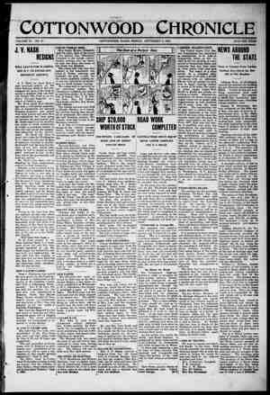
2 By OSCAR P, AUSTIN \¥Statisti cian, The National City Bank of | New York. The difficulties which accom. Yanied the transformation of the twenty pre-war countries of Eu- rope into the thirty which now appear on the map of that conti- nent recall some interestin features of the process by \\'hwg the territory of the United States, which is now about equal to that of all Europe, was enlarged ad- Justed, readjusted into the fifty political divisions which now appear upon the map of our own countri;. We have been husy, very busy, in this big country of ours in the comparatively short period since the Dutch, the Span- ch and the English were ‘“staking out” their respect- fve claims upon the Atlantic frontage from the southern tip of Florida to the frozen north. But when we recall the steps by which that area was united, enlarged, populated and then divided and sub-divided into territories and states, we fInd many interesting and almost forgotten incidents. How many of the twenty million ;-r\oplx- living in the states of Ohio, ndiana, Illineis, Michigan and Wisconsin recall the fact that the area which they now occupy was at one time a part of the province of Quebec? How ma eople in t ish, v of the nine million tates of Wisconsin, owa, Mi ota and a part of the Dakotas realize that the section which they now occupy was once & part of the territory of Michigan, whose area in 1834 was eight times as much as that when the territory was established and six 25 as much as that of the pres- f Ilichigan? erritory of Mi mcluded the area forming present states of Iowa, Nebraska, North Dakota, South Dakota, Ark as, Missouri and a part of present area of Minnesota, roming, Montana, Kansas, Okla- r homa, and Colorado. The Territory of Indiar included what is now end a part of the Dakotas. ! Texas, which is now nearly twice as large as any other state of the Union, is at the present time only about two-thirds as big &s when admitted, and a part of in 1804 innesota her original area now forms parts | of five other states, New Mexico, | Oklahoma, Kansas, Colorado and | ‘Wyoming. The area inquished to the Common Urion by the thirteen original states after the close of the Revolutionary War now forms Eart or all of thirteen other states | aving a combined area greater than that of the present area of the original thirtcen which gave their western area te the Common | Union. . o % The Nation's Beginnings The first permanent settlement TEMBER 8, 1822, The Process by Which Our “Original Thirteen” Were Enlarged and Transformed into the Present Fifty Political Divisions. colonies. The British flag at that moment flew from the southern tip of Florida to the northern border of Canada, for Florida had mean- time been brought under the Brit- ish flag; and following this exten- sion of Canadian Government over the area lying south and west of the Great Lakes, the colonies claiming that area joined with those which were already clamor- ro C_O/F470 N TP 1786, North Carolina 1784, and 1790, Soutk Carolina 1787, and Georgia in 1802, Vermont, which had been claiined by the State of New York as a part of her area, purcaased independence from that state by paying $30,000 and was subsequently admitted to the Union as the first new state. Maine, which had been claimed and governed by Massachusetts for LOUISIANA PURCHASE 1803 o’ nubuefluenuy divided into Alabama and Mississippi. LI The Territories Absorbed into the Union The steps by which these two great areas, the Territory, North- west of the “'hio and the Territory South of the Ohio, were trans- formed into separate territorial and state organizations cannot be NVIOO DI1LNVILY or MEXICo Map Showing “ae 2éc:wunr 2 of Torellory Which Entsred into the Formation of the United States, ing for indepencence, and a!l of | the British colonies on the North American continent except Florida at the south and Canada at the north united in the declaratior. cf 1776, declaring themselves no lon- ger colunies but free and indepen- dent states. . e The First Territories. It was at the close of that mem- orable struggle, when the peace treaty with Great Britain in 1783 gave to the new United States cf America the entire area ext-n'ing to the Mississippi at thz west anc | the Canadian border at the north, that the question of the method of government in that grea‘ intevie= area cama to the freet and de- manded eolution, Seven of tYa colonies—Massachuset’s, Connuc- ticut, New Yorl Virginia, !'orth Carolina, South Carolina, and Georgia—claimed that their orig- inal grants extendea wesiwvard {o the Mississippi. if not f2rtn.r, £ad T>» “igning of the Declaration of Independence, after the Paintiny by Trauobul- at the Capitol in Washington. Furopeans on the area now wn as the United States was that of the Spanish at St. Augus- tine, Florida, in 1565, the English at Jamestown, Virginia, in 1607, the Dutch at the mouth of the Hudson in 1651, the Swedes on the west bank of the Delaware in 1637, while the French who made taeir first permanent scttlement in Quebec in 1608 soon extended their claims southward by ex- ploration and settlement, and by 1850 were claiming all of the area of k | | | [ | | it had also become apparent that these claims i many instances over-lapped each cther; and with the magnanimou~ spirit then pre- vailing of fealty to the new gov- ernment the le; seven states oze by one ceded to the Commor. Union all of their wesiern clei 7e area thus ced- 2d to be £ into new states with iadividu-! privileges and | powz"s eju-l t) those which gen- arained by the Great Lakes and | the St. Lawrence. By 1655, “New | Sweden” had been taken over hy the Dutch; in 1664 the Dutch ter- ritory of “New Netherlands” was taken over by the English. The Franch meantime had extended explorations down the Mis- | pi to its mouth and were cleiming all of the area drained | by that river as a resuil of “oriz- i explorations” of the valiey. s claim, however, was resisted the English who assumed tnst colonies fronting on the At- were by their charters to | extand across the continent to the “‘Smrth Sea,” a- the Pacific was tken called, and in the war be- tweap France and England over this question the French were de- feetsd and ordered to transfer beir territorial claims to Great which they proceeded to do, sacretly, however, ceding to aic their claims to the western » of the Mississippi Valley, waich, nowever, was subsequentiy re celed to France by the Spanish fiuvarpaient, 1t wes when the English Gov- erpaeat found itself in full pos- scarion of not only Canada but the entjra ssstern half of the Missis- sivp! Valley that its parliament | at'srreq to the Province of Que- bee, for temporary government, the avas now known as Michi- gan., Obio, Indiana, Illinois, Wis- consin_aud a part of Minnesota, and this action by the British Parliament proved the “straw that broke the camel's back” with certain of the colonies which ¢elaired thet their original grantc ex'ended to the Mississippi River, and increased their willingness tu joinr in a v ment for Indepen- dence, then pending h erously re'nquished their claims upon the territory in question. hug ceded to the Com- mon Unior, »y the seven states above namea, lying between the Allegheny-Cumberland range on the east and the Mississippi on the west, exceeded in area that retain- ed by the “vriginal thirteen,” ag- i avout 500,000 square the yrymnt area of the “origmal tuniri.en” aggregates [ "l"' Y more than a centurn was finally released hy the Naso~ghvoy'ts Legislsture and in 1830 mge & state cf the Union. One of the first questions which arose efter the cescion by the colonies of their territory lying west of the Allegheries was as to the method of its government. A Congressisma' Committee was ap- poin‘ed to consider the matter 7ith J+@erson at its head and the result ¢ its labors waa the pres- entation of a plan of wkhich Jef- ferson was understood to be the authar by which the area in ques- tion should be divided into ten nevr states, eom- of the names be- ing crawn f£rom the Greek and Latn and o'hers from Indian phraseology. The pcninsula ly- ing between Lakes Huron and Michigan was to be called “Cher- onesus,” that bounded by the Wa- bash, Ohio ard Mississippi “Poly- potemia,” that betwsen the Upper Chio and the Greet Leles “Metro- potamia,” while other parts of the area were given the nama ¢f “Ilincie,” “Assenisippla,” “Wicr- igania,” “Sylvanis,” *Jaravzys,” end “Washington.” The above measure devised and recommended by Jefferson was ac- cepted by Congress and put upon the statute books but before sieps had been taken to carry it into actual operation it was repealed by the celebrated “Ordinance of 1787" establishing the “Territory Northwest of Ohio” of which Gen- eral Arthur St. Claire was made the first governor, in 1788, and the first Territorial Government, which was to prove such an im- portent factor in the development of the westein area, put into oper- ation. General St. Claire estab- lished the scat of the government of thet enormous territory at the little village of ‘“Losantiville” which he renamed “Cincinnati” in honor of the “Society of the Cin- cinnati” of which he, as an officer of the Revolutionary War, was a member. In 1790 an act was pass- ed for a similar form of govern- ment in a part of the area south of the Ohio which was to be desig- nated “The Territory South of the Ohio,” the provisions of that act being similar to that which estab- lished the territory northwest of the Ohio excep! the omission for the southern territory of the pro- viso found in that for the northern territory with reference to slav- ery; the act establishing the Ter- ritory Northwest of the Ohio ex- cluded slavery while that proviso was omitted from the terms under which the Territory South of i Ohio was established. Thls tory South of the Ohio di however, inciude tie XxuArck, area which rer:ai followed in detail within the limi- tations of this discussion. Ken- tucky was admitted 2s a state in 1792, and Tennessee in 1796. In 1200 the western part cf the terri- tory northwest of the Chio and ex- tending to the Mississippi and the Canadian line was cut off and es- tablished under the title of Indiana Territory and in 1808 the State of Ohio established. In 1805 the ter- between Lakes Michi- gan_and Huron was established as the “Territory of Michigan” o2nd it later proved a convenient reocleus to which to attach for {saporary governmeni tae sec- rivory lyinfI aickess of Alaska, tion lying west of Lake Michigan which included the area now known as Wisconsin, Iowa, Minne- sota, and parts of North and South Dakota. When the original Terri- tory of Michigan applied in 1837 for admission as a state, there existed a bitter dispute between that territory and the State of Ohio as to the boundary line be- tween them, Michigan claiming an area which would have given her the port of Toledo at the southern tip of Lake Michigan, and to settle that cispute amic- ably, Congress gave to Michigan the area now krown as the “North- ern Peninsula,” which subsequent« ly became extremely valuable through the development of its reat copper and iron and timber interests. The section at the west which had been temporarily at- tached to Michigan was then es- | tabiished as the “Territory of Wis- ’ while the area lying di- west of the State of Ohio S Lowm TERRITORY o MISSOURI e 1819 TERRITORY OF NEW MEXICO 1859 V) MIMOT gy TEXAS As rapuces 830 TERR IToRy e Map Shnwh;' how the Vast Territories - the United States were Lroken Up Gradually and Formed into States. but 326,000 square miles. These cessions of the western territory by the colonics did not occur si- multaneousiy but began with New York in 1781, Virginia in 1788, control ol‘Virgginin until its admis- sion as & #t'fa in 1722, nor Ad it ipsluds the wyctern are~ of Geor- { 2| Massachusetts 1735, Connecticut | unde: the title of “Indiana Terri- tory” bad mcantime been divided ia%0 the territories of Indiana and (llinois. Indiana became a state in 1218 and INinois in 1818, The Territory South of the Ohio | paying $10,0C0,0% was transformed into the State of Tennessee. The western section of Georgia, ceded to the Common Union in 1803 became the Terri- tory of Mississippi and later the Territories of Mississippi and Ala- bama until they were finally ad- mitted as States of the Union in 1817 and 1819, The transformation of the western front of Virginia into the new state of West Vir- inia in 1862-3 was an incident of the Civil Wn:. o The Lousiana Purchase. Meantime had come the first eat addition to the area of the vited States, the Louisiana Pur- chase. The urea west of the Mis- sissippi which had been originally claimed by France as a result of exploration and been secretly ceded to Spain in 1762 prior to the expulsion of Frence from the con- tinent, had subsequently been again secretly transferred and re- ceded by Spain to France in the year 1800. The complete control of the mouth of the Mississippi River by the United States was extremely important to its people and the commercial interests, controlling as it did the exit from the Mississippi Valley to the Gulf of Mexico, and when the cession of the area west of the Mississippi to France in 1800 became known a commission was sent to France by the United States Government to negotiate for the purchase of the area adjacent to the mouth of the Mississippi and including the city of New Orleans. The French Gov- ernment, however, fearing a loss of the entire western area to Great Britain offered to sell it all to the United States for $15,000,000, of which $11,260,00" would be in six per cént bonds of the United States Government and the remainder to be paid to citizens of the United States having claims against France, and when this treaty reached, Washington it was quick- ly ratified, in October 1803, and the ares of rhe United States thus doubled by a single stroke of the pen. This “Louisiana Purchase” thus completed in 1808, which as above indicated more than doubled the area of the country, included 883,- 000 square miles, while the total area prior to the purchase was only 828,000 square miles. The entire new area was given the title of the “Territory of Louisiana® but in 1804 the southern tip was cut off and estublished as the “Ter- ritory of Orieans” and in 1812 the “Territory of Crleans” was admit- ted to the [Inion as the State of Louisiana and the remainder of the purchase given a new title, the “Territory of Missouri” with its capital at the city of St. Louis. Later, after the States of Arkansas and Missouri had been cut ¢ irom | sequently became a part of the present states of New MeRico, Oklahoma, Kansas, Colorado, and Wyoming. he ink on the documents which admitted Texas as & state of the Union was s:arcely dry when there began a series of events which ex- tended the arvea of the United States from the western border of Texas to the Pacific Ocean, A dis- pute between the United States and the Mexican Government re- glrdlng the southern boundary of 'exas resulted in the war between the United States and Mexico, which began in 1846, and in wsich the Mexican area ihen known as New Mexico and Upper California was over-run and captured by American troops, and at the close of that war was attuched to the United Statee on payment of $15,- 000,000 by the United States tothe Mexican Government, though this sum was subsequently increased by the assumption of about $3,- 000,000 of debts of the Mexican Government to citizens of the Uni- ted States. By this absorption of the former Mexican area of New Mexico and California our territorial area was extended to the Pacific Cast. This great area obtgined from Mexico was sub-di- vided into California which was in 1860 admitted as a state without *territorial probatien,” and the remainder divided into the Terri- tories of New Mexico and Utah. Subsequently Utalt was transform- ed into three Territories, Utah, Nevada, and Colorado and they were later admitted as states. New Mexico was later sub-divided into the territories of Arizona, and New Mexico and subsequently ad- mitted as states. Simultaneously with this exten- gion of our government over the area lying petween Texas and the Pacific—the Mexican cession—an agreement had been reached be- tween the Uniwed States and Great Britain regarding our claims to the “Oregon Country,” and in 1848, the very year in which California and New Mexico were acquired from Mexico, the area lying north of California was established by the United States Government as the “Territory of Oregon,” and the pingle year 1848 thus brought us our entire Pacific frontage. The Oregon Country became the Terri- tory of Oregon which was subce- quently subdivided into the Terrie tories of Oregon and Washington and later z¢mitted as states, the eastern part having been cut off and forminyg the Territory of Idaho and a pzrt ¢f the Territory of Wyoming. In 1253 a small area lying'south of the Territory of New.Mexico was purchared from Mexico for sum of $10,000,000 to settle a boundary divpute &nd attached its southeastern section ticz re-| to the Territory of New Mexic), | L North and South Dakota, while tho “Indian Territory” in a greatly reduced form became the present State of Oklahoma, This story of our expansion and transformation into the states would not be complete without o word about our non-contiguous areas, Porto Rico, the Phillippino Islands, Hawaii, the Virgin fs- lands, Guam, ’i‘utuiln, an t}m Panama Canal Zone. Porto Rico and the Philippine Islands fell into our hands as a result of the war with Spain, though we paid to Spain $20,000,000 for e full can- cellatian of ner claim to the Phile lippines, Guam which lies east of the Philippincs and had been held %y Spain was taken over by the nited States in 1898 during the war _with Spain, Our little island of Tutuila in the Samoan grou fell to the United States in 189! after long years of joint adminis- tration of tha group by Great Bri- tain, Germany and the Unitedy States. Its chief value is in its’ fine harbor which is designated as: the best in tiia South Pacific whilo: the harbors in the Philippines and Hawaii are the best in the North. ern Pacific. Hawaii, which had been knocking vigorously for ad.’ mission to the United States from Signing the Treaty which gave Loulslana Territory to this Country. 1898 on downward, was admitted in 1898 and the group of islands established in 1900 as the Territory of Hawaii. The Virgin Islands which lie just east of Porto Rico were purchased from Denmark in 1917 for $25,000,000, the chief pur- pose being their control as a naval station, The Panama Canal Zone, five miles on cach side of the Pan- ama Canal, was in 1903 granted in perpetuity to the United States by the Panama Government on the payment of $10,000,000 by the United States, to be followed by annual payments of $250,000 be- ginning nine years after the agree- ment. Alasks, the Philippines, the Hawalian Islands and Porto Rico have theic own legislative bodies, but the goverror i3 in each case dss'gnatad by the President of the Map of the United States Showing the Growth Within its Borders, and its Territories and Ialand Dependencles, mainder was re-nained the “Indian Country.” While this “Indian Country” was | transformed into ter- re slowly bein. ritorial and state divisions, th | came the second addition to the area of the United States in the purchase of Florida from Spain to which country Great Fritain had re-ceded it in 1783. a tion of its purchase from Spein was to be the payment by the United &tates OF various claims by Amarican citizens against the Spanish government, w'm‘ch amounted when paid, inclzding in- terest, to §6,500,000 and the terri- tory thus purchaced subseguently became, in 1625, the State of Flor- ida. L B Texas and the South-West. The third addition to our terri- tory came in the form of the State of Texas wh.ch had in 1836 seced- ed from Mexico and established itself as an independent republic and immediately made apglication for admission to the United States. This application was, how- ever, rejected by Congress when made in 1837 and again in 1844, but in January, 1845, Congress passed an act giving its “consent that the territory properly. includ- ed within the Republic of Texas may be erected into a new state to be called the State of Texas” joint resolution a as a state of the both House and Sen being thus scdmitt | without preliriinery “arodation” | as a territorv. Suhsequeatiy Cone grss purchased from the Siate of Texas & part of is original area, and tae 124,000 square miles thus purchased suv- oo ity The considera- | the area thus added being about 38,000 square miles. P Our Recent Accessions. In 186/ 2laska with its enormous territory wns purchased from Rus- sia 10r ¢7,200,0u), end is now the only area o coatinant~l Uni- ted Ctates still governed £s a ter- 1ltory, aii cther parts of the great continental areas added having | been transformned into states after passing through their “probation period” as territories. e great Territory of Nebraska at one time a part of the still greater Terri- tory of Missouri was sub-divid- ed iato the States of Nebraska and United States. In the Virgin Islands the governor is also designated by the President of the United States and the legislative functions are~ vested in a “colonial council.” The governors of Guam and Samoa are naval officers of the United States, designated by the President for that service, and the Governor of the Panama Canal Zone is an army officer designoted for that servies by the President The population of the Philippine ielands is about 10,600,000, Porto A@fcc 1.800,000, Hawaii 250,000, Alash- 88,000, the Virgin Islands 28910, {ne Pan- ama Canal Zone 22,0 FROM 180 Terrttorial Division Louisiana Purchase ....... Florida Texas .. Oregon Territory . Mexican Cession ........ Purchase from Texas . Gadsden Purchase .. Alaska Hawaiien Islands Perto Rico Samoan Islands ... Additional Philippine: Panama_Canal Zone . Virgia Islands .... izens against Mexico. admission of Texas, {¢}—area purchzsed from Texas, amounting to 128,754 is not included in the column of Aren -Mt:‘ Socamee % became a part of the area of the Ucitad ADDITIONS TO THE TERRITORY OF THE UNITED STATES TO 1922 ear Area Added Pfared.Price SquareMiles Qallars 876,025 156,000 70,107 6 489,748 (a) 389,795 —_— 288,689 523,802 () 36,211 599,446 2 19,250.000(b) 10,000,000 10,000,000 7,200,000 20,000,000 100,000 12,600,000 (d» 25,000,000 2,936,863 124,539,748 (b)—oZ which $3,2£0,000 was in payment of claims of Ainerican cit- mils, States with, io | (d)—includes annual payments to 1922,