The Key West Citizen Newspaper, June 15, 1951, Page 7
You have reached the hourly page view limit. Unlock higher limit to our entire archive!
Subscribers enjoy higher page view limit, downloads, and exclusive features.
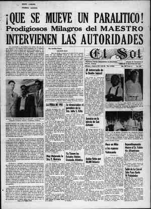
50—Legal Notices (Continued) » described as follows: et mencing at the intarmeneidh ar the south Mne of Section. §, Township .66 South, Range 23 East, and the ‘southwesterly right-of-way line of Peninsula po Fag ot said Riggs’ Subdivi- sion, run northwester! the southwesterly PAAR ied line of Peninsula Street for a distance of 306.01 feet te point, said point. being ‘at’ the northeast corner of Lot 7, Block 1 of said Riggs’ Subdi- vision; thence at right angles and southwesterly asong the northwesterly line of said x 1 7 for a distan ah of 60.04 feet to ae point of beginning of the a bottom land hereinafter . ed; from said point of 8 fig continue southwest- ae erly ‘along the © northwesterly ia line of sald” Lot ‘7, extended a for a Wistithce of 165 feet, more 5 or less, to’ the edge of an’ exist- $ ing chapel; ‘therice meander the edge of Said existing chan- nel in a ‘aouitheasterly direction for a distance of 75 feet, more or less, to Where said edge of channel intersects the south- easterly. line of Lot 7, extended southwesterly; thehce run hortheastemy along the south: easterly line of Lot 7, extended ed, southwesterly for ‘a distance of 140 feet, more or less, to the approximate spting tide line: thence meander the approxi- tide line in a north- westerly direction for a dis- tance of 75 feet, more or less, back to the point of beginning, containing 0.25 aéres, more or less, ALSO ¥ A parcel of bay bottom land in Boot Key Harbor at Hog ay. Monroe County, Florida, lying Westerly of Lots 8 9 and 10, Block I of Riggs’ ‘Subdivision 4s recorded in Plat Book 2, Page 68, Public Records of Mon- roe County, Florida, and more particularly described as lows: Commencing at_ the i terseetion of the south line of Section 8, ‘Township 66 South, Range 32 Bast, and the xouth- westerly right-of-way . line of Peninsula Street of said Riggs’ Subdivision, run. northwesterly along the Bouthwesterly -right- of-way line of said Peninsula Street for a distance of 231.01 feet to a point, satd point be- at th ortheast corner of 3, Block 1 f said Riggs’ bdivision; thence at right a and southwesterly along the northwesterly line of said Lot & for a distance of 6% feet to the point of beginning of the bay bottom land hereinafter de- seribed; from sald point of he- ginning continue southwesterly along the northwesterly line of said Lot 8 extended, for a dis- tance of 140 feet, more or less, the edge of un existing chan- ; thence meander the edge of ‘said existing channel in a southéasterly direction for a distance of 170 feet, more or less, to a point where sald edge of existing channel intersects the south line of Section 8, Township 66 South, Range 32 Bast; thence run east along the south line of Section & Town- ship 66 South, Rang East, for a distance ‘of 165 feet, more or less, to a point where said Section Line intersects the shoreline of Boot Key Harbor; thence meander the shoreline of Boot Key Uarbor in a north- westerly direction for a dix- tance of 225 feet, more or less, back to the point of beginning, containing 0.82. acres, more | or less, ALSO A parcel of bay bottom lang in Hoot Key Harbor at Hog Key, Monroe County, rida” lylrig Westerly of Le Block 1 of s8° Subdivision as recorded at Hook Public of “OUnty, Florida, and bed as folk Commenc- ing at the intersection of the south line of Section &, Town- ship 66 South Range Rast, and the soutowesterly — right- of-way line of Peninsula Street of id Riges’ Subdivision, run northwesterly along the south- westerly right-of-way line of Peninsula Street for a distance of $81.01 fest to a point, sald point the northeast corner Kk 1 of said Riggs’ § ; thence at right angles and southwesterly along the northwesterly ti of said Lot 6 for a distance of 73.7 feet to the point of begin- hing of the bay bottom land hereinafter deséribed; from said point of beginning — continue southwesterly along the north- westerly tine of Lot 6, extend- . ed, for a distance of 175 feet, more or less, to the edge of an existing channel; thence mean- the edge of said extating in @ southeasterly di- for a distance of 75 r less, to Where said edge of nel intersects the southeasterly line of Lot 6, &x~ tended, southwesterly; thence northeasterly along the southeasterly line of Lot 6, ex- tended southwesterly, for a dis- tance of 165 feet, more or. less, to the approximately spring tide line; thence meander the approximat) spring tide line in a northwesterly direction. for i jeden ha SB lhiies more or nt of be- ) winiing, epnitainin .29 acres, 4 more or less. ALSO of bay bottom Jand in Harbor in Section §, ‘Township 66 South, Range 32 See mise ai a Rast, easterly of Lots 2, 3, 4, 5 and 6, Block 3 of Riggs’ Sub- division us recorded In Plat Book 2%, Page 68, Public Reg- ords of Monroe County, —Florl- at Hog Key, Monroe County, orida and im ticularly sribed as follows: Commene- rf at the northeast corner of said Riggs’ . said corner also to as the point of bi ginning of the property here- Inafter described, run easterly along the southerly right-of- way line of U, 8. Highway No. 1 for a distance of 100 | feet, more or less, to the original centerline of the former pass between Hog Key aca; thence meander or channel and Key winal centerline of said pass or chinnel in a easterly and southerly di- distance of 380 to a point; riy to a point reetion tor a feet, more or hb thence tun weste: on the shoreline where the di~, viding line of Lots 6 and 7, Block 3 of said Riggs’ Subdivi- sion intersects said shoreline; thence meander ithe shoreline along Lots 2, 3.4, 5 and ti, Blook 3 of said Riges' Subdivision in a northwWesterty’ direction: fora dintanceiet 38ofeet, more or less, back toothe point of begin> ning, cormtaining 0.48 aad more or lesm & parcel of bay bottom. in Boot Key Harber in Sections & and 17, Township 66 Sourh, Range 32 Hast, south of Block 3 of Riggs’ Subdi- n AS recorded in Plat Book 2 Pake 88, Public Records of Monroe Coanty, Florida at Hog Key, Monroe ‘County, Plorida and more. particularly’ deserib- eas follows: Commencing at the southwest corner of Lot 7% Block 8 of said Riggs’ Subdi- vision, said corner also te be known as the point of begin: ning of the bay bottom. land hereinafter described, Pum southeasterly and on a line ti is at right angles to U. S. High= way No. Ll. for a distance of 1300 feet, more or less, to the edge of Boot Key Harbor Chan- nel; thence meander the rd proce Baten 3 yea Channet in 1 erly directio: distance of 170 fest, more OF Jess, tovdopoint; » thence. rum (Continued) 50—Legal Notices northwesterly and on a line Tight angles to U. S. Highw; No. } for a @istance of 1850 feet, more or less, to a point on the shoreline where the divid- ing line between Lots 6 and 7, Block % of said Riggs’ Subdivi- gion intersects said shoreline; thence meander. the shoreline on tke southerly side of said Lot 7 for a distance of 170 feet, more or less, back to the point of beginning, containing 5.0 acres, more oF less. The Purchaser is required to pay the advertising cost and documen| ary stamps. | The Sale, if and when made, shall | be subject to the Trustees reserving unto themselves 7 of the phos- phate, minerals and metals and | 10% of the petroleum thereon or thereunder. THE TRUSTARS OF INTERNAL {MPROVEMENT, FUND reserve the eight toon t the de. BY ORDER of the 'PRUSTFES of the Internal Improvement Fund of the State of. Plorida. FULLER WARREN Governor ELLIOT, Sec, Trustees I. J. Fund may 18-25;juni-8-16,1951 v May 10th, 1961 & OTICE \NOTICE is hereby given that the Trustees of the Internal Improve- ment Fund of the State of Floridu, Wwassee, Florida, Pursuant to Law, will offer for sale, for objections only, in ‘alla- hassee, Florida, at 11:00 o'clock a.m- June 19th, 1961, the land in MO; ROB COUNTY, described as follows A parcel of bay bottom land | in Boot Key Harbor at Key Va- ca, Monroe County, Florid south of Lot 22, 23, and 24, Block 1 of “Parrish Subdivi- sion” as recorded in Plat Book 2, Page 18, Monroe County, Florida Records, said parcel of bay bottom land also being a part of Section 9, Township 6 South, Range 32 East, and Se 16, Twp. 66 South, Range 3 Bast and more particularly, de- seribed as. follow: ‘ommenc- ing at the intersection of the went line. of Section 9, Town- ship 66 South, Range 32° Mast, and the southerly right-of-way line of U. 3. Highway No. 1, run northeasterly along the south- erly B/W of U.S. Highway No. 1 for a distance of 1125 feet to a point; thence with ‘a aé- flected angle to the right of 94° 45° and south for a distance of 319 feet, more oF less, to the southeast corner of the W% of Lot 21, Block 1 of sald “Par- rish Subdivision”, said south- east corner also to be known as the point of beginning of the property hereinafter describ- ed; from said point of begin- ning continue south for a dis- tance of 1080 fee! pre or less, to the north edge of the exi ing dredged area in Boot Key Harbor; thence at right angles and along edge of said existing dredged area for a distance of 130 feet, more or less, to a point, said point being on the prolongation of a line due south from the northeast corner of Lot 1, Block 3 of said “Parrish Subdivision"; thence north on said prolongation of a line due south of the NE corner of hot 1, Block 3 of sald “Parrish Sub- division" for a distance of 930 feet, more or less, to said NE corner of Lot 1, Block: 3 of sald “Parrish Subdivision’; | thence » meander the ‘original shoreline ») as platted isa northerly andi easterly direction for a distance.” of 280 feet, more of less, ‘biick ») to the point of beginning, eons « taining 3 aeres, more or : leks, ALSO A parcel of bay bottom land in , Boot Key Harbor at Key Vaca, Monroe County, Florida, south of Lots 19, 20 and 21 of “Parrish Subdivist corded in Plat: Book 2, Pame 18 Monroe County, Florida Rec ords, said pues of bay bottom land also beitig a part of Sec tion 9, Township 66 South, Range ‘32 Rast, and Section 16, Township #6. South, Range 32 Hast, and more — particularly described an follows?” Commencing at the intersecs tion of the West line of Section 9, Township 66 South, Range 32 last, and the southerly R/W line of US. Highway No. 1, run northeasterly along the southerly R/W line of U. S. Highway No. 1 for a distance of 1225 feet to a point; thence with a deflected angle to the right of 94° 45’ and south for & distance of 307 feet, more or less, to the SE corner of W% of Lot 19, Block 1 of said “Pat- Tish’ Subdivision,” said south- east corner also to be known as the point of beginning of the bay bottom land hereinafter described; from said point of beginning continue south for a distance of 835 feet, more or jess, to a point; thence at right angles and west fora distance of 100 feet, more or less, to a int on the prolongation of a ine due south from the south- west corner of the Ei, of Lot 21, Block: 1. ot sald “Parfish ubdigision’; ghence north along Lipa 845 fect, | Smo! he corner fot. es eck. 1, em ee rrish. AR gaivision A thence meander the shoreline in an. easterly and northerly and southerly, direction for a @istance of 190 feet, more or. Jess, back to the point of begin- ning, containing 2 acres, more or less, ALSO ‘A parcel of bay bottom land in Root Key Harbor at Key Vaca, Monroe County, Florida, south of Lots 18 and 19, Block 1 of “parrish Subdivision” as re- corded in Plat Book 2, Page 18, Monroe,County, Florida “ Rec- ords, said parcel of bay bot- tom land also being in Section 9. Township 66 South, Range 82 East, and Section 16, Town- shi South, Range 32 Bast, find more particularly describ- ed as follows: Commencing at the Intersection of the west line Gf Section 9, Township 66 South, Range 32 Bast and the southerly R/W line of U. Highway No. 1, run northeast- erly along the southerly R/W line of U. 8 Highway No. 1 for a distance of 1300 feet to a point; thence with a deflected Angle to the right of 94° 45° and South for a distance of 324 feet, , more or less, to the SE corner of Lot ji: Block, 1 of seid “Pa: Tish Subdivision”, said SE & her also to be known as the point of inning of the bay bottom land hereinafter de- scribed; from sald point of be- inning continue south for a jistance 45 feet, more or less, to & ; thence at right angies and west for a distance of 75 Lge Reape bed vey i . int on the jon gation corner of the F Block | of said “Parrish Sub- division’; thence north along said prolongation for a dis- tance of 840 feet, mote or less, to the SW. corner of the E% of Lot 19, of said “Par- rish jon“; thence mean- der the shoreline in an easter~ direction for a distance of 80 feet, more or less, back to the . of beginning, containing "S$ ucres, more or less. ALSO parcel of bay bottom land in ‘ - a at Key Vaca, nty, Florida, south of Lots 15, 16 and 17, Block 1 parish Subdivision” as re- oF ded in Plat, Book 3, Page 18, County, Florida Ree- t ‘said aa ie bay bot- tom landy abelng @ part of, $0—Legai Notices «Continned) Section 9, Township 66 Souvin, Range 32 East, and Section 16, Township 66 South, Range 32 East, and more particularly de- scribed as follows: Commenc- ing at the intersection of the west line of Section $, Town- ship 66 South, Range 32 Bast, and the southerly R/W line of U. 8. Highway No. 1, ron north- easterly along the southerly R/W line of U Highway No. 1 for a distance ef 1450 feet to a point; thence with a deftected angle to the right of 94° and “and south for a distance of 0 feet, more or less, to the southeast corner of Lot} Block 1 of said “Parrish division”, said southeast c also to be known as the point of beginning of the bay bottom land hereinafter described; from said point of beginning continue south ‘for a dis! of 820 feet, more or les: poin thence at right angles and west for a distance of 150 feet, more or less, to a point on the prolongation of a line due south from the southwest cor- er of Lot 17, Block 1 of said ’arrish Subdivision thence north along tion for a distance of 845 more the southw Block 1 of thence in a mean- south- puthwesterly and south direction for a distance of 330 feet, more or less, bs to the point of be- ginning, containing 2.5 acres, more oF less The Purchaser is required to pay the advertising cost and document- ary stamps The Sale, if and when made, shall be subj. tees reserv- | ing un 75% of the phosphate, nd metals and 50% petroleum thereon or | theret )F INTERNAL : FUND reserve the right to reject the sale. BY ORDER of the Trustees of the Internal Improvement Fund ‘of the State of Florida FULLER WARREN, Governor Attest F.C. Elliot, See. #4, 1, Pund may} Tallahassee, Florida May 10th, 1951 PICK NOTICE 4a-hereby given that the Trustees of the Internal Improve- ment Pond sof the Pursvant to , WHM offer for sale, for objections only, in Talla- hassee, Florida, at 11:00 o'clock am. June 19th, 1951, the land MONROE COUNTY, described as follows: of Florida, | in| the advertising c: 50-——Logal Notices (Confinued) ginning continue sovih for a Sintanoa, of £65, fest. mors, or less, to @ po thence at right angies and West for a distance of 75 feet, “more or less, to a point on the“Protengation of a line due south from the SW corter of the BY of Lot 19, Block 1 of said ‘Parrish Subdi- vision”; thence north along said_prolongatian for a distance of 840 feet, more or less, to the SW corner of the E% of Lot 19, Btock 1, of sald “Parrish Subdivision"; thence meander the shoreline in ap easterly di- rection for a @istdnce of 80 fect more or lessyhaek to the point of beginning, containing 1.5 acres, more or less. ALSO ttem laa in it Key Vaca, Monroe County, Florida, south of Lots 15, 16 and 17, Block 1 of “Parrish Subdivision” as re- corded in Plat 2, Page 18, Monroe Count’ ‘terida Rec- ords, said parcel of bay be tom land also being a part of Section 9 To ip 66 South, Range 32 Bas! jd, Section 1 Township 66 South, Range st, and inore particularty scribed as follows: Commenc at the intersy of the west line of Seet ‘ownship 66 South, Rang at, and the southerly R/W line | of U. 3. Highway No. 1, run. northea erly along the southerly R/W line of U.S. Highway No. 1 for a distance of 1450 feat to a point; thence with a deflected nele to the clght of 94° 4) nd south for a distance of eet, more or Tess; to the sou st corner of Lot 15, Block 1 sald “Pay ubdivision”, id southea! r also to be own as tite int. of begin- ning of the bly @bottom land hereinafter ad; from aid point.ot ing continue south for a_ distance of feet, more or less, to a point; thence at, right angles and west a distance of 150' feet, more to a point on the pro- on of a ling due south from the - southwest. corner Lot 17, Block 1 of gaid “Par. rish Subdivisign"; thence north, along said prolongation fer a distance of 845. feet, more or lexs, to the southwest corner of Lot’ 17, Block 1 of said “Par- rish Subdiyision"; thence mean- der the shoreline in a south- y, southwesterly and Sterly direction for a distance of 320 feet, more or jess, back to the point of be ginning, containing 2.5 acre more or less. The Purchaser is required to pay st and document- ary stamps The Sale, if and when made, shall $0—Logai Noiic shoreline and b Hog Key, Monro ida in Section puth, Range 32 particularly described as ful | lows: Commencing at the | section of the line of ne of South tersection also | the point of property sterl) ngles to U. S. fer a dis more or less, to the of Boot Key thence meander of Hoot Key, Har! Chan a southwesterly ee tic | distance of 210 feet, | less, to a point on the an existing channel; the northwesterly and < | right angles to t | No. i for a distance more or , to th corner of an existing thence meander said and shoreline, north , in an easterly, northeast northwesterly and northeast | ly direction for a_ distance 607 feet, m r less, back to the POR, containing 4.5 m or less h Harbor the north a The Purchaser is required | the advertising cost and documen and n made, sh | be subject’ to the reser * % of ae Y oleum h STHE TRUSTEES OF IN 1,| foreground) {IMP VEMENT FUND re i serious inj BY ORDER of the Tru Internal Improvement Fu f ; FULLER WARREN uy Nv . ey + | oY meen Vodka For Russian) F. Cc. ELLIOT, Sec >» a | | Preis 1 Ballet Stars, But | junt-8 tA ADAAAAAAAAAAD AAD aD KEY WEST i | Of Days Gone By |: parcel | be subject to the Trustees resery- fun. Boot K jing unto themselves 75% of the Tht Monroe | phosphate, minerals and metals and r ip of Lots 21, 150% of the petroleum thereon or he R } of “Parrish &§ ‘ as | thereunder. 5 recorded in Plat Book 2, Page | “pHi TRUSTEES OF INTERNAL | 18, Monroe County, Florida Ree- | jm@PROVEMENT FUND reserve the | of th ords, said parcel of bay bot right to reject the sale. | Tt tom ‘Jand also being & part of BY ORDER of the Trustees of the Section %, Township 66 South, | internal improvement Fund of the | st r Range Kast, and Sec. 16, | State of Flori | in 1 Twp, 66 south, Range 32 Bast LLER WARRE | ar and more particular! lexerib- Governor | . no one fdas follows: Commencing at | attest: | Taken From The Files : intersection of the west | — ¢. RLLIOT, Sec., | siebe sf of Section 9, Township 66 | pustees J. 4. Fund ; _Of The Key West Citizen t South, Range 32 é t, and ae | May18-25;jun1-8-15,1951 AAAAASSAA. vvvv) right-of-way line of | | oaeeeead cet Highway No.1, run north- | - | ies master B long the, southerly | Seerecenney. Tieriae 10 YEARS AGO confines Tmo: R/W of U. S. Highway No. 1 bat Ae Bb L8G )> Arma chaefer, sacts es ‘4 for acstietance.of.1125.feef tog’ | |) | NQTICH | _ Armand Schaefer, associate pro- | to waiters a Boint: thence with, a Ree | pAQTICR 8 printadt rmprote: | ducer with Republic Productions, | she say fe to the yight of. 3 1 : : . , ee outh for a distance of 319 -4ment Fund oF ehie Stafevor Florida fand William Morgan,“ilm direct-| All of Jfeet, more or less, to the south. | Pursuagt to Law, 4 will offet fer. ier, arrived here today to make a| whatcve dust corner ‘of the Wi of Lot | sitle, COB omy ral BY ie Fe NY dreliminary study of loeat ra RT 21, 1BWcRel tag ewsaid, {Rarrish, hagre locida, at 1 { <M.” Ju! 4 A ys vy logations fc oth 3 Subdivision”, : said" noutheas A RE the land In MONRO) the filming of “Mercy Island,”) them ha cornér Gise: to he Known 9p Niaah at! t-selling novel by Theodore | with his n nint of beginning of the prop- |), 7 Bt-s S x eodore | W lis me Priv neretnarter deaeriie vitro. "pS ene tt ae tothe! Ketel said point of “beginning. con- The pair flew fro: olywood, | comfiture o tinue south for a distance of beat Ly Ag Miarni se Selwncs, a hepa . 1080 fee ore or Je! o the “ Ml ore z display ¢ forth ¢ of. the ¢xisting a lngrem DF De eies Buen: morning. After making a} uniouched AL aed pap erat rs Agee se NT gin Tract |Sight-seeing tour of the city, they | - long edge of said. existing 7,ana,_ mo partion arly de- | will board a boat to inspect some € 1 redgied afea for adintance of | sertbed an fovows: Eemiaulne of the small islands south of Key oaay 130 f more or jens, to a a al . S59 point, said point being on the, | érly extell ‘et soar ‘b- | West. 4 he prolongation of atime due south easterly Ine of Petronia ‘Street ANnNIVE from the “northeast. .¢orner of Lot 1, Block 3 of said “Parrish Subdivision”; thence north on said prolongation of a line due south of the NE corner of Lot 1, Block 3 of said “Parrish Sub- division for a distance of 980 feet, more or less, to sald N& corner of Lot 1, Block 8 of snid “Parrish Subdivision”; thence meander the original shoreline as platted in a northerly and easterly direction for a distance of 280 feet, more or leas, back to the point of beginning, con- taining 3 acres, more of les® ALSO ‘A parcel of bay bottom land it Poot Key Harbor at Key Vaca, Monroe County, Florida, south of Lots 19, 20'and 21, Block 1 of “Parrish Subdiviste as re- corded in Plat Book 2, Page 18, ; Montbe: County, » Florida , Rec- erds, sald parcel of bay bot- tom land also being a part of Section 9, Township, 66 South, Pange 32 Hast, and Section 16, fownship 66 South, Range 32 Dast, my rtioularly desorib- encing at the. west South, Range 32 Hast-and the southerly R/V lnee of U.S. Highway No. ruf northeast+ erly gions the southerly | R/W Ynevof U.S. Highway 1 for feet to with a deflécted right of 94° 46° istance of 307 to the BE % of Lot 18, fa distance of 122 point; thence angle to the and south for a feet, more or le corner of the W Block 1 of said “Parrish Sub- _ division”, said southeast cor- ner also to he known as the point of beginning of the bay bottom Jand hereinafter de- scribed; from said poing of be- ginning continue south for a distance of 835 feet, more or less, to a point; thence at right angles and west for a distance of 100 feet, more or less, to a point on the prolongation of a line due south from the south- west corner of the E% of Lot 21, Block 1 of said “Parrish Subdivision”; thence north along. said’ prolongation 835 feet, more or less, to the SW corner: of the E% of Lot 21, Bloek 1 of said “Parrish Sub-) division”; thence, meander the Shoreline in an easterly and northerly and noutherty direc: tion for a distance of 190 feet, more or less, hack to the point of beginning, containing 2 acres, more or less. ALSO A parcel of bay ‘bottom land in Boot Key Harbor at Key Vaca. Monroe County, Florida, south of Lots 18 ‘and 19, Block 1 of “Parrish Subdivision” as re- corded in Plat Book:2, Page 18, Monree County, Florida Ree- ords, said parcel of bay bottom land also being in Section 9, Township 66 South, fe 32 East, and Section 16, Township 66 South, Range 32 Bast, and more particularly desertbed as follows: Commencing at the in- tersection of the west line of Section 9, Townshtp $6 South, Range 32 East and the south- erly R/W line of U.S. High- way No. run northeasterly along the southerly R/W_ line line of U. S. Highway No. 1 for a distance of 1300 feet to a point; thence with a deflected angle to the right of 94° 45° and south for a distance of 324 feet, more or less, to the SE corner of Lot 18, Block 1 of said “Par- rish Subdivision”, said SE cor- ner also to be known as the int of beginning of the hay s bottom fan ereinafter de- scribed; from saidepoint.of be-, gp ROE ge | Pursuant the. Northeasterly intersects litte of Sait Pond or Bay Road, and running theres Southeast- erly along othe, Northeasterly lire of Salt Pond or Bay Road a distance of 7148 feet and 6 inches, more jor'fess, to a potat on the Northengterly extension of the Northwéxterly” line “of Pine or Monroe Street; thence running in @ ortpeasterly al~ rection along fhe Notthwesterly line of Pine \G#iMbnrge Street, If, extended, hay gigtante ‘0 etna Oe thd. intatateting the ‘existing ) bulfiiead tine - in Jarrison Blihty! i extertied Southeasterly;, thence running Northwesterly: parallel to the Northeastenty, ine of Salt Pond or Bay Raad,a distance of 148 feet 6 Incltes, more. or less, to a point of the Northeasterly extension of the southwesterly line of Petronia, Street If ex- tended; thefeetranning in 'a SovthwWesterlya firection, and atong satd Kort retail ex- tension of ‘the’? Southeasterly line of Petronia:Bgreet 189: fee point of bs 64 of an 4 S the advert ary stamps: Dae : The Sale, if and Whénimade, shall be subject’ to. the."Trustees reserv- ing unto themselves: 75% of | the phosphate, minerals and metals and 50% of the petroleam thereon or thereunder, > THE TRUSTEES OF INTERNAL IMPROVEMENT ‘PUND reserve the right to reject the sale BY ORDER of the Trustees of 1. 1. Fund of the State of Florida. FULLER WARREN, Governor Troktees 1. 1.) Fund : may 18-25 ;funt-8-15,1951 Tallahassee, Florida May 2ist, 1951 NOTICE NOTICE is hereby given that the Trustees of the Internal Improve- ment Fund of the State of Florida, to Law, will offer for wale, for objections only, in Talla- hassee, Florida, at 11:00 o'clock AM, July 3rd, 1953, the land in MONROE COUNTY, described as follows: A parcel of bay bottom land in Boot Key Harbor, westerly of . and adjacent to the west shore- line of Hog Key, Monroe Coun- ty, Florida, in Section 17, Township 66 South, Range 32 East, and more particularly de~ ribed as.follows: Commenc- ing at the intersection of the westerly shoreline of Hog Key and the north line of Section 17, Township 66 South, Range 32’ Bast, said intersection also to be Known as the point of be- ginning of the property here- inafter deseribed, Ton west along the north Hae at Section 17, Township 66 th, Range 22 Bast, for a distance of 200 feet, more or less, to the edge of an existing channel; thence meander the ede of said chan- nei in a southeasterly direction for @ distance of 210 feet, more or less, to the northwest cirner of an existing bulkhead; thence meander the shoreline of Hog K in © northerly. al tor a at tance of 1 t, more or less, back to the of peatestn, containing 0.94 acres, more less. eae : is : parcel et: + PB oe 2 and in. ify 4 erly and siutherly’ sajucent erly and southerly and adjacent 835—-Ada much-talked actr ed by week is begun, specifications i: the navy department th have revealed. Rep. Bernie C. Papy’s bill creat- ing the post of. police lieutenant in Key West, will give the mayor authority to lift one of the patrol- mén to a $115 a month job. ulptor anc 28, 1922. 1861 | Heink, the 1 can operatic born 1936, $250 was stolen from the Horse- shoe Bar on Sunday. The thief dropped more than $40 in change and bills as he ran from the scene nounée the when discovered by a_ waiter! j¢ their dau during the robbery. The thief ev- | Cae ta Dou idently knew the combination of prepa ‘ in Au Gonzalo Bezanilla of this city,! er whether vacationing in the mountains of) necessi 1 Colorado was aware of the past! gram will r ten days heat wave here. He wrote | prices.” friends that he was sending, un- j der seperate cover, a package of}. The hist ; Mountain snow. }came about pans’ BIG 10 IN. POPULAR RECORDS 10 IN. CLASSIC RECORDS _ al, and none And to the dis-} Construction of the three mill- 3—Edward M, Cook, Union ion dollar aqueduct from Florida r, diplomat, governor of Col- City to Key West must be com- orado Territory, born Steuben- pleted within 180 days after work | V Ohio. Died Sept. 9, 1909, s of her generation, born in New Orleans. Died Aug. 10, 1886. 1858—Frank EB. Elwell, eminent born in Concord, Mass. Died Jan. Ernestine From the editorial’ pages 6f {Phe Gitizen: “fhe people of the Unit led States ‘are beginning. to wond- ee ym on the continent than Mr. and Mrs. Ygnacio Cobo an-' because of European relations. | REMINGTON Long Playing Records 12 IN. RECORDS CLASSICS - POPULAR ONLY $2.19 EACH They Don’t Drink | Italy—(}—Twel- Russian ‘ballet ists have been per-| e trom behind the take part in the} tival in Flo- having any aiety and music, artists lead a glum by an agent in Rome vank hotel, but ul secret stairway to ind they talk to bassy Florence knows, they that is, all but] t of her nd is conve sts eat| wine or s been| bar. the bartenders, of vodka still ds the} there, / rsaries Isaacs Menken, the about and colorful 1 artisiec personality, Schumann. nuch-beloved Ame and concert singer, stria. Died Nov. 17, approaching marriage iter Solita Carmen glas V. McCarthy. those expenditures- by the defense pro esult in inflationary Monroe Doctrine more as a matter of $1.49 _. $1.79 RUBBLE AND FALLEN TREES litter the West End.section of Richmond, Va., iornado that did damage estimated at $1,000,000 or more. in the wake of a lid : One tree has fallen on a taxicab (left pinning the driver, Bruce Corr, He was trapped for more than an hour but escaped y. The violent storm injured five persons and left 140 homeless. The Citizen wetcomes expres- sion: fair 200 words, and write on PEOPLE’S FORUM | of the views of its read- t the editor reserves items delete any The writers and confine the letters: less requested otherwixe. your publicizing the various cooperation in issued by this office. It is our purpose to keep the people of the Key We and currently advised of the Federal The various the prima ballerina of | Provisions a Ulanova. But she] Regulations. sation| You have kindly publ eful of what} contributed much | accomplishment of this objective. Your good newspaper is render-| > menu and ask}ing a real service to the people} suff. And not one of|of) this community and we wish liquor} for your continued progress. With kindest personal regards of the fam * PRAISES GIBBS AND Dear ng it |"RENDERING REAL SERVICE” Editor, The Citize: We would like to take this op- portunity of expre: and your father, Mr. L. |man our sincere appreciation for prominetly releas Pr: Sincerely yours, FREEMAN L. KNIGHT, Area Rent Director. June 13, 1951 DOROTHY RAYMER Editor, The Citizen: Sir, ne xide Sixnature must accompany will be published un- to rea ful- releases zed has indeed to A prophet not without in his own. city.” explanation for that he prophet probably 2 mething “out of kilter” in the neighborhood and annoyed the neighbors lling attention to it. Prophets usually get in troublé . by talking too much. My interest Key West, and my disregard popularity, leads me to suggest at, if Key West knows what: is good for. it, it will incorporate in- to its building code a provision that the plans for every dwelling must include plans for a practical and sanitary cistern. We all agree that the needs af ., r armed forces take precedence over civilian needs, it is not diffi+ cult to determine that the watet |supply, locally and nationally, is diminishing. It is certain that, the needs of the Navy will increase, There, was a.time when we de- | pended “upon our cisterns. At that : ime, ifvwas noted that Key West was free of the enteric diseases, in towns with polluted | water suppdy i ted | Old Timers will remember that 4 | soon after the mainland water was | made available, some eager beav- jer thought up a plan to drum up business for the water salesmen, .-: : F |by having the City condemn, all * ‘ save by ¢ 1 | | cisterns, i | That ordinance was revoked. at | the next meeting of the city fath;: .. - ers, and those who had good ¢is+ * |terns continued to enjoy them, | ,.... Here is an episode of long ago. The citizens of Key West, and) Two disappointed boomers were ae THE KEY WEST CITIZEN ave! returning from Key West onthe. . fortunate in having two column-|F. E. C. “Flyer; and nothing im ists, Bill Gibbs in, “This Rock of| Key West was good enough for. Ours,” and Dorothy Raymer in| them, especially its water. An old: “Conch Chowder" who are inte: Cuban lady sitting in the seat ested in Key West and its people| back of them, stood it as long as arid write about it and them rather! she could. She thrust her head-in . + than to try to re-write a column) between them and demanded, that has already been re-written| “What's the matter with you? We several times based on a sketchy | don’t drink out of a dirty hole.in report by a man who was not al-| the ground like you people do, | lowed to report what he saw, in| We get our water right from the first place; but who had to| Heaven.” And, nothing is tog gogd ___ .. dream up a column if he wanted! for Key West. So, let us have our to keep his job. Key West is an easy place in| which to get interested, a fact! whic! h explains wh: FOR HOME or We Are Prepared To Furnish You With Clear, was'noted: terns when the Navy says, _ “Sorry, but bd 9 STEPHEN C, SINGLETON. © | Miami, Fla. F i “id . 12, “No amount of dry affect the Eskimo dog. apse S , t & ¥ : i Pare